Petra · Ma'an Governorate, Jordan
Petra — The Caravan City and Its People
An audio walk through Petra, from the tombs at Bab as Siq down the narrow gorge of the Siq to the carved front of the Treasury, and on through the Nabataean city to the temple of Qasr al Bint.
Narration in English · Stop 1 is free
 Tour no. 42
- Stops
- 11
- Distance
- 4 km (2.5 mi)
- Time
- About 165 minutes
- Route
- Moderate walking route
Listen before you buy
Stop 1 · Bab as-Siq: the Djinn Blocks and the Obelisk Tomb
Stop 1 is free. Listen before you buy.
The walk
An audio tour from the tombs of Bab as Siq through the gorge of the Siq and past the Treasury to the temple of Qasr al Bint, at your own pace
Petra was the city of the Nabataeans, Arab herders who grew wealthy on the incense trade, moving frankincense and myrrh out of southern Arabia to the Mediterranean ports, and who settled a dry valley by storing the water of its winter floods and its springs. The walk sets out among the Djinn Blocks and the Obelisk Tomb at Bab as Siq, where a bilingual inscription in Nabataean and Greek names Abdmanku as the maker of a family tomb, and passes the dam and tunnel that sent the floods away from the gorge. Inside the Siq two worn reliefs of drovers with laden camels were carved before the paving below them was laid, and at its end stands the Treasury, never a treasury but a tomb most probably made while Aretas IV was king, its solid stone urn scarred by shots from people hoping to break open the treasure of Pharaoh that local legend placed inside it.
Beyond it the walk passes the rows of tombs on the Street of Facades, where the Bdul, the Bedouin of the Petra valley, kept goats and lived in tents, rock shelters and empty tombs until most of them were moved to the new village of Umm Sayhoun in 1985. It goes on past the theatre cut from the mountain and the Royal Tombs, one of which Bishop Jason made a church in 447, by the public fountain and the colonnaded street that the earthquake of 363 brought down, and up to the church where carbonised scrolls of a sixth century family archive were found in 1993. It ends at Qasr al Bint, the main temple of the city and most likely the house of the god Dushara, still standing to its full height.
Route notes
The stops
About each stop · narration stays in the app
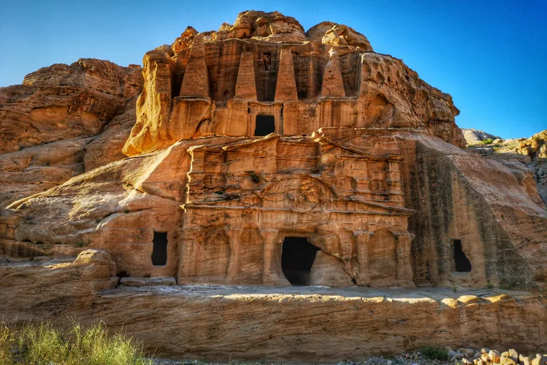
Photo: John Romano D'Orazio · Wikimedia Commons source · CC BY-SA 4.0 · Cropped to the recorded 3:2 source rectangle and resized from the exact hash-bound source input. Bab as-Siq: the Djinn Blocks and the Obelisk Tomb
Bab as Siq is the wide valley between the ticket gate and the mouth of the Siq, where the main trail passes block monuments cut free from the rock on every side and, stacked in the cliff face, the Obelisk Tomb above a triclinium. The route stops here for the way the Nabataeans marked their dead: the eroded cloaked figure set in the niche of the Obelisk Tomb is thought to stand for the tomb's patriarch, set above five burial niches, and a nefesh like each of the tomb's four obelisks was a standing stone, often crowned with a blossom, a pine cone or a stylized crown, and many such stones line the paths into Petra. The stop works from the wide gravel and packed sand track of the valley, about half a kilometre past the ticket gate, with both monuments in view; there is no need to leave the track, and there is no shade.
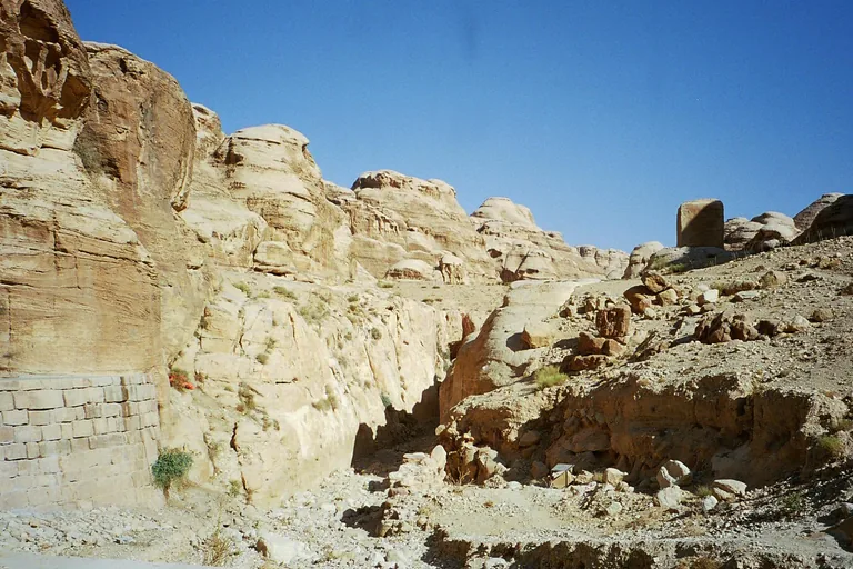
Photo: Clem23 · Wikimedia Commons source · CC BY-SA 3.0 · Cropped to the recorded 3:2 source rectangle and resized from the exact hash-bound source input. The Dam and the Tunnel at the Mouth of the Siq
The mouth of the Siq is where the natural cleft through the mountain begins, with a modern dam across the old flood course and the rock cut tunnel that the Nabataeans made to send the floods of Wadi Musa into Wadi al Mudhlim and Wadi al Mataha. The route stops here for the water that shaped the city and the way it is watched today: the diverted floods fed reservoirs, cisterns and dams in and around Petra, and since 2014 a siren system linked to rain forecast stations and two water detection points has guarded the gorge, and on 9 November 2018 it sounded minutes ahead of a torrent, when hundreds of visitors reached higher ground and were later evacuated. Beyond this point the floor of the Siq is uneven ancient and modern paving, slippery when wet; most rain falls in winter, and if sirens sound or staff tell you to leave, leave the Siq at once.
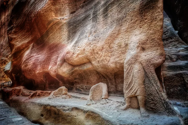
Photo: John Romano D'Orazio · Wikimedia Commons source · CC BY-SA 4.0 · Cropped to the recorded 3:2 source rectangle and resized from the exact hash-bound source input. The Caravan Relief in the Siq
The Caravan Relief is a pair of carvings at the major bend roughly halfway through the Siq, drovers leading camels on the south wall and on the west wall, one panel about nine and a half metres long and the other a little over ten, with two cult niches cut into the corner between them. The route stops here because the relief, older than the water channel cut behind it, shows the trade the kingdom relied on, and the way down passes other traces of travel through the gorge: the niche of two sacred stones uncovered by the Department of Antiquities in 1977, which faces people leaving the city, and stretches of the road that the Nabataeans paved at a lower level and the Romans paved again after the annexation of AD 106. The relief is at the foot of the wall beside the path, where the way is narrow and busy, so step to the side to stop and look; satellite positioning is weak in the gorge, so the stop may start a little early or late.
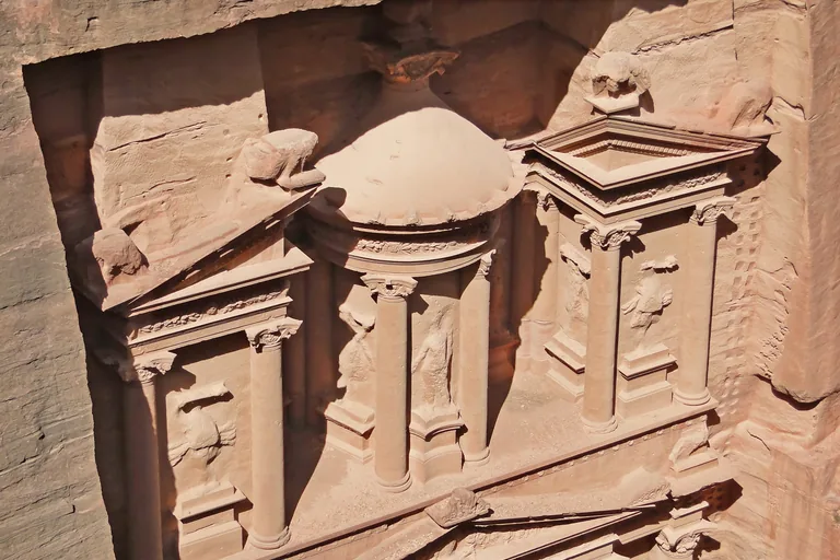
Photo: Bernard Gagnon · Wikimedia Commons source · CC BY-SA 3.0 · Cropped to the recorded 3:2 source rectangle and resized from the exact hash-bound source input. The Treasury (Al-Khazneh)
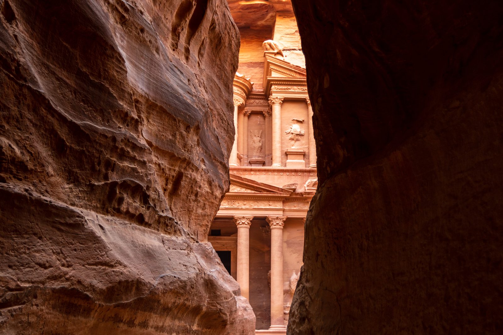
The Treasury, Al Khazna in Arabic, is the carved facade of a Nabataean tomb that stands where the Siq opens, its six Corinthian capitals topped by a frieze of winged griffins and vases among scrolls. The route stops here for what the monument became after the Nabataeans: in 1934 the American Schools of Oriental Research carried out clearance work there, until 1968 one of its chambers served as a store of the Department of Antiquities, in 1972 the antiquities inspector had it cleaned out so that tourists with sleeping bags could spend the night inside, and a restoration in 1974 consolidated two eroded base columns and rebuilt the main steps leading up to it. The stop works from the sand of the plaza where the Siq opens, about two kilometres from the ticket gate; the plaza is often crowded, entry to the chambers behind the facade is restricted, and the walk does not go inside.
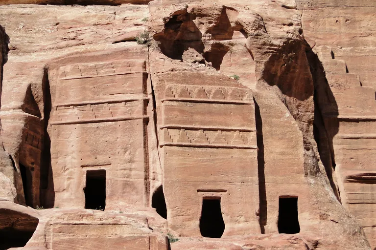
Photo: Bernard Gagnon · Wikimedia Commons source · CC BY-SA 3.0 · Cropped to the recorded 3:2 source rectangle and resized from the exact hash-bound source input. The Street of Facades
The Street of Facades is the stretch of the main trail beyond the Treasury, in the Outer Siq, where monumental Nabataean tombs are cut into the southern cliff face, among them Tomb 70 with its bricked up crenellations and, across from it, Tomb 825, topped by half crow steps and an Egyptian cavetto cornice, with a vaulted recess inside. The route stops here for the people of the valley as well as its dead: in 1923 the Emir Abdullah met the sheikhs of the Bdul, who chose government trusteeship of the land in return for a guarantee of their traditional rights to live on it and use it, and in their fields beyond the park the Bdul have used ancient Nabataean barrage dams against erosion and ancient threshing floors for their harvests. The trail here is wide sand and loose gravel, open and unshaded, with stalls along the way; the tombs are seen from the trail, and the walk does not climb into them.
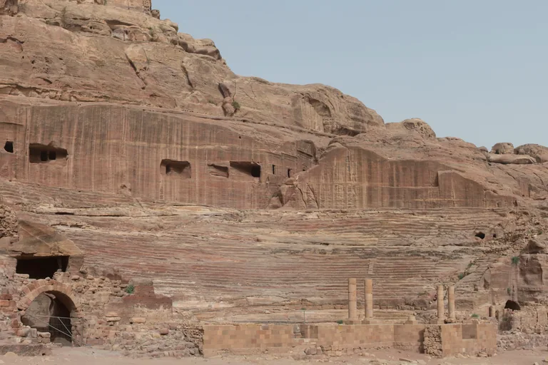
Photo: Dosseman · Wikimedia Commons source · CC BY-SA 4.0 · Cropped to the recorded 3:2 source rectangle and resized from the exact hash-bound source input. The Theatre
The theatre is cut into the mountainside at the foot of the High Place of Sacrifice and faces east, its rows of seats hewn from the rock and divided into sections by passageways and by stairways radiating from the centre. The route stops here for the hands that shaped it after it was cut: by one account a son of Aretas IV, Malichus II, enlarged it, the Romans rebuilt its outer wall after the annexation, its floral capitals are in a typically Nabataean style, and pottery of the early first century AD was found in its drainage system. The theatre is seen from the main trail across the dry wadi bed, and the walk does not enter it; the ground is open, with no shade.
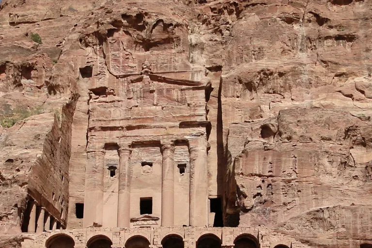
Photo: Bernard Gagnon · Wikimedia Commons source · CC BY-SA 3.0 · Cropped to the recorded 3:2 source rectangle and resized from the exact hash-bound source input. The Royal Tombs and the Urn Tomb Church
The Royal Tombs are four great tomb facades carved into the western side of Jabal Khubtha above the city centre, with the Urn Tomb at the right end, the Palace Tomb at the left, and the Silk and Corinthian Tombs between them. The route stops here for what the facades hide: the Corinthian Tomb has four chambers inside and traces of four water basins in front, and behind the Palace Tomb a dam and a water reservoir drained rainwater to a pool cut to the north of the monument's podium. This is a view stop on the open trail across the wadi bed from the cliff, with no shade; stairs climb steeply to the Urn Tomb terrace, but they are not part of the walk.
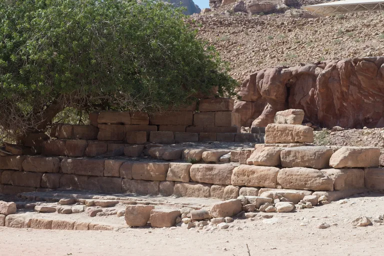
Photo: Dosseman · Wikimedia Commons source · CC BY-SA 4.0 · Cropped to the recorded 3:2 source rectangle and resized from the exact hash-bound source input. The Nymphaeum and the Colonnaded Street
The Nymphaeum is the stepped podium, now only its lowest courses of masonry, of the city's public fountain near the junction of Wadi Musa and Wadi al Mataha, where the visible stretch of the Colonnaded Street begins and runs to the Temenos Gate. The route stops here for the street's later story: six Nabataean columns once adorned the fountain's front, the Department of Antiquities and the British School dug along the street in the late 1950s and early 1960s, and flash floods have ruined much of it, leaving only a short stretch of the original paving stones. The ground at the start of the street is open and flat, sand and old paving, and the tree over the fountain podium gives the first shade since the Siq.
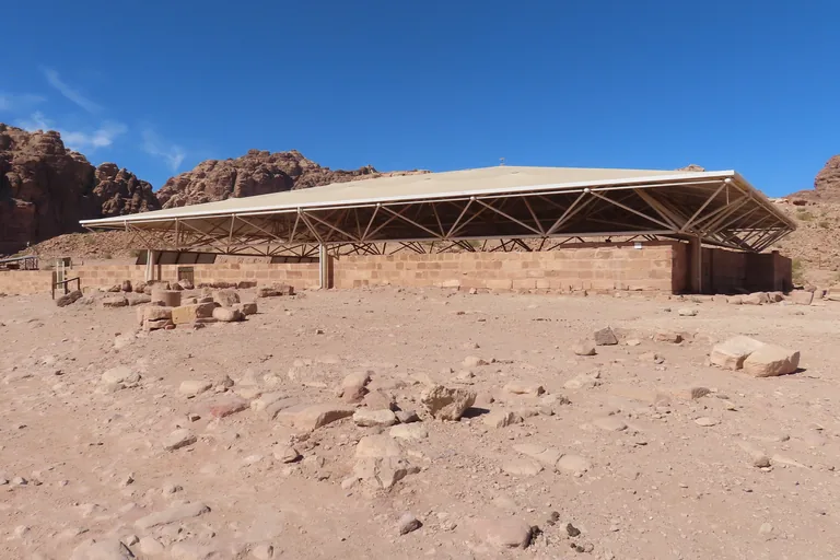
Photo: Fallaner · Wikimedia Commons source · CC BY-SA 4.0 · Cropped to the recorded 3:2 source rectangle and resized from the exact hash-bound source input. The Petra Church and Its Papyri
The Petra Church is a basilica in three parts, about 26 metres from east to west and 15 from north to south, one of a group of three churches, with the Ridge Church and the Blue Chapel, built over earlier Nabataean structures and tombs. The route stops here for what happened to the scrolls after they were found: a team of papyrologists from Finland conserved them in Amman in 1994 and 1995, laying the fragments on archival paper between glass plates, the texts show that laws issued by the emperor Justinian in Constantinople came into force in Petra within about a year, and some documents are shown at the Jordan Museum in Amman. The church is reached by a short, steep, unpaved path up from the Colonnaded Street, with loose stones and no shade; whether the shelter is open on a given day is not confirmed, so the stop works from outside it.
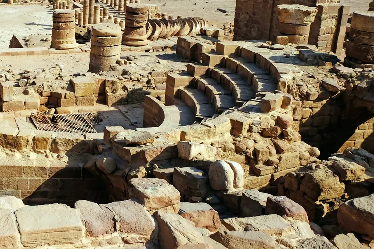
Photo: Davide Mauro · Wikimedia Commons source · CC BY-SA 4.0 · Cropped to the recorded 3:2 source rectangle and resized from the exact hash-bound source input. The Great Temple and the Garden
The Great Temple is a complex of some 7,560 square metres, entered through a monumental gateway and rising through two open courts, with a garden terrace of about 67 by 53 metres beside it to the east. The route stops here for the work behind the display: excavation found a drainage system running under the complex, baths on its west side and a workshop for making plaster moulds at its south end, and the garden's pool and terrace were fed and watered through stone conduits and ceramic pipelines, in a paradise garden that seems to have been made for Petra's wealthy. The stop is heard from the level street; the temple precinct is up a long flight of uneven stone stairs and the garden terrace stands about six metres above the street, and neither climb is needed for the stop.
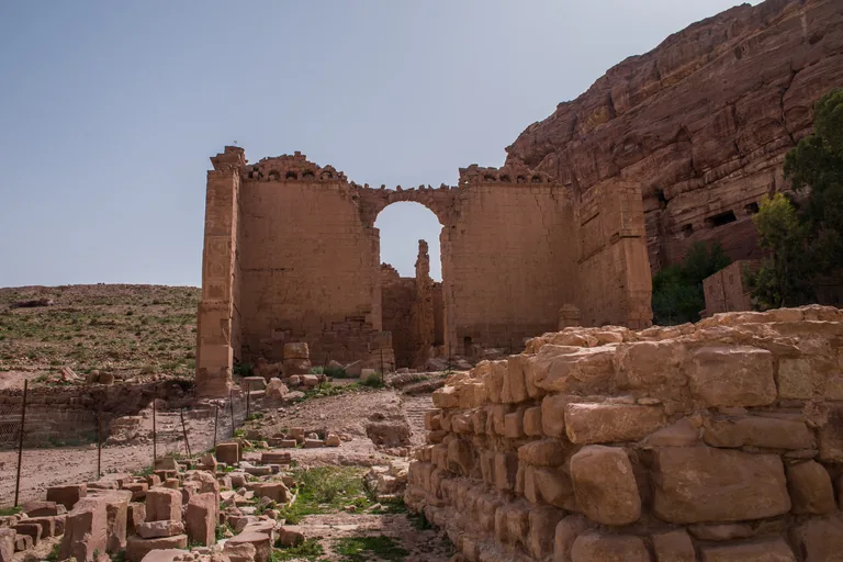
Photo: Abdul baqi · Wikimedia Commons source · CC BY-SA 4.0 · Cropped to the recorded 3:2 source rectangle and resized from the exact hash-bound source input. Qasr al-Bint, the Temple of Dushara
Qasr al Bint is the main temple of Nabataean Petra, standing on a podium in an open sacred precinct at the west end of the Colonnaded Street, entered through the Temenos Gate. The walk ends here for the setting of worship: the Temenos Gate, most likely of the time of the emperor Trajan and built after the street was paved, had a large central bay and two smaller side entrances, and its east face bore carved panels of busts of gods alternating with vegetation; the temple front had Corinthian columns covered in stucco, and inside, the central of three rear compartments held a platform for the god's images. The precinct is open, sandy and without shade; the way back to the Visitor Centre is the same path through the Siq, about four kilometres, so allow time and water, and the steps up to the Monastery that start here are a separate climb.


Local context
Before you go
The walk covers about four kilometres one way, from the ticket gate below the Visitor Centre at Wadi Musa down the park's main trail through the Siq to Qasr al Bint, and the same four kilometres back uphill: about eight in all. It ends at Qasr al Bint, near which there are two restaurants, and the way out is back the way you came.
On the ground
Access and surfaces
About four kilometres one way from the ticket gate to Qasr al Bint, and the same four kilometres back uphill: eight in all. Entry needs a park ticket; check prices, where tickets are sold and opening hours locally. The ground is gravel and packed sand in the open valley, uneven ancient and modern paving in the Siq, slippery when wet, and soft sand and loose gravel beyond the Treasury; the short spur up to the Petra Church is steep. Most rain falls in winter, when the Siq can flood: if flood sirens sound or staff tell you to leave, leave the Siq at once. There is little shade after the Siq. From May to September midday heat is dangerous: start early, carry plenty of water and wear a hat and sturdy shoes. Animal rides are offered inside the park; whether to use one is your choice.
Frequently asked
Plan the walk
- How long is the Petra audio walking tour?
- Allow about 165 minutes. The route covers 4 km (2.5 mi) one way in 11 stops, including walking and listening time; the return to the gate retraces the same four kilometres, uphill.
- Where does the Petra tour start and end?
- It starts at Bab as Siq, just past the ticket gate below the Visitor Centre at Wadi Musa, and ends at the temple of Qasr al Bint at the far end of the colonnaded street. The way out is back through the Siq.
- Do I need a ticket for the walk?
- Yes. Entry to Petra Archaeological Park needs a park ticket; check prices, where tickets are sold and opening hours locally.
- Is the route hard going?
- In places. The paving in the Siq is uneven and slippery when wet, the ground beyond the Treasury is soft sand and loose gravel, and the way back is uphill. There is little shade after the Siq: from May to September start early and carry plenty of water. If flood sirens sound or staff tell you to leave, leave the Siq at once.
- Will the Petra audio tour work offline?
- Yes, after download. Audio, stop text, images, and GPS triggering work without data; the live map background still needs a connection.