Muscat · Muscat Governorate, Oman
Muscat — Mutrah, the Harbour Town
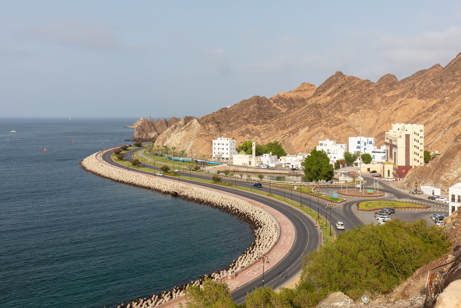
An audio walk along the bay of Mutrah, the old harbour town of Muscat, from the fish market through the souq and below the fort to the watchtowers of Riyam.
Narration in English · Stop 1 is free
 Tour no. 45
- Stops
- 10
- Distance
- 3 km (1.9 mi)
- Time
- About 90 minutes
- Route
- Easy city route
Listen before you buy
Stop 1 · The fish market and the bay
Stop 1 is free. Listen before you buy.
The walk
An audio walking tour of Muscat along the bay of Mutrah, from the fish market through the souq and below the fort to Riyam Park, at your own pace
Mutrah lies on its own bay a short way along the coast from Old Muscat, and it was long the place where the trade of the sea met the caravans that came down from the interior. The walk starts on the seafront beside the fish market, which Muscat Municipality rebuilt and opened in 2017, then turns back from the water to Bait al Baranda, a merchant's house named for its long screened balcony, which an American mission rented as its dispensary from 1909 and which is now a museum of the city's history. Along the corniche it passes Sur al-Lawatiya, the walled home of a merchant community whose ancestors are thought to have come from Sindh; the quarter is private, and the stop is told from the road outside.
In the souq the route follows a lane of gold and silver shops, reaches the roofed crossing in the lanes local people call Souq al-Dhalam, or market of darkness, and goes up the main lane inland, which is thought to follow the old hollow known as Khor Bimba, where the road to the interior began. Back on the shore it pauses at the souq gate, above the beach where the customs house stood in 1908, when the town's merchants brought in rice from Calcutta and cloth and spices from Bombay, and below Mutrah Fort on its rock, the frame for the Portuguese century on this coast and the fall of Portuguese Muscat at the turn of 1650. The last stretch follows the open corniche to a rocky point with the port in view and ends at Riyam Park, where a modern monument shaped like an incense burner stands on the headland above the park and small round watchtowers sit on the rocks.
Route notes
Route and itinerary
About each stop · narration stays in the app
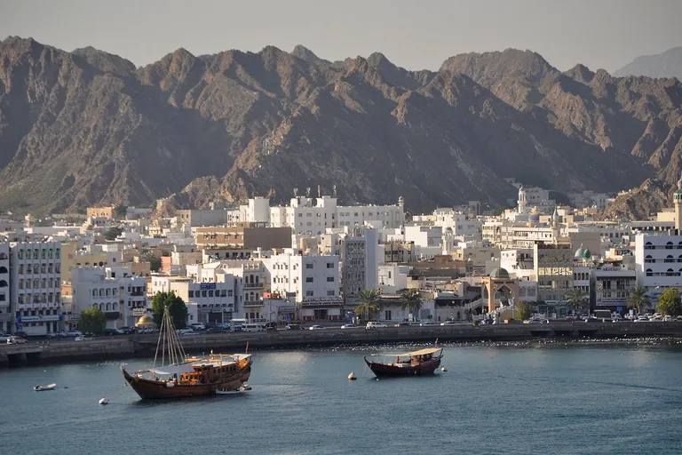
Photo: bhart9070 · Wikimedia Commons source · CC0 1.0 · Cropped to the recorded 3:2 source rectangle and resized from the exact hash-bound source input. The fish market and the bay
The stop is on the promenade at the western end of the Mutrah corniche, beside the fish market that Muscat Municipality opened in 2017 under a canopy of aluminium and steel. The route starts here for the bay as a working harbour: the British survey of 1908 found it shoaling steadily from eight fathoms at its mouth to the beach, about twelve hundred yards from the entrance to the shore, with the town running along the water for about three quarters of a mile. The new market was planned with its own areas for landing, chilling and packing fish, beside a meat market, a cafe and a restaurant. The seafront is open and paved with no shade at midday; the market works in the morning and is usually shut by early afternoon, so the stop is planned to work from outside at any hour, and cars use the service road around the car park.
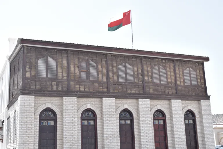
Photo: Mustafa Al-Elq · Wikimedia Commons source · CC BY-SA 4.0 · Cropped to the recorded 3:2 source rectangle and resized from the exact hash-bound source input. Bait al Baranda, the merchant's house
Bait al Baranda is a two storey merchant's house set back from the bay in Mutrah, now a museum of the history of Muscat. The route stops here for the house's later lives: the British Council rented it in 1972 and fitted it out with study rooms, a library and offices, it was put forward for the Aga Khan Award for Architecture in 1979, and the museum that opened in December 2006 uses paintings by foreign artists and old maps to show the trade routes that ran through the port of Muscat from the seventeenth to the nineteenth century. The house is a ticketed museum, usually closed on Fridays and over the middle of the day, so check its hours and fee locally; the stop works from Bait al Baranda Street outside, which runs through the car park without a pavement, so stand at its edge clear of moving cars.
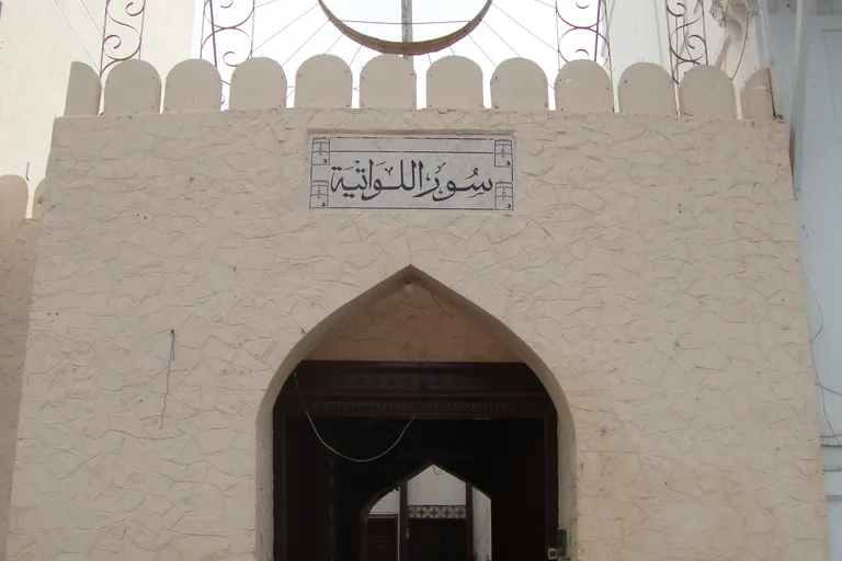
Photo: AmeerLawati27 · Wikimedia Commons source · CC BY-SA 4.0 · Cropped to the recorded 3:2 source rectangle and resized from the exact hash-bound source input. Sur al-Lawatiya, the walled quarter
This is the walled residential quarter of the Lawatiya merchants of Muscat, set about the middle of the old town on the seafront and reaching some way inland, with tall houses and a large mosque behind its wall. The route stops here for the people behind the wall: families of the community have traded in incense, jewellery and cloth as well as in general goods, some now live on the Batinah coast and elsewhere in the Gulf, and in 1908 the British survey found that most of the merchants of the quarter were small traders and shopkeepers in cloth and spices, with only a few dealing on a large scale. The quarter is private: the stop stands on the public corniche pavement outside the wall, so do not go in, do not block the gate, keep voices low near the mosque and do not photograph residents; the pavement is narrow, beside parked cars and fast traffic.
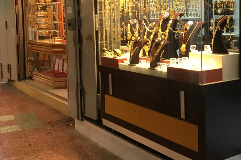
Photo: Scott Edmunds · Wikimedia Commons source · CC BY 2.0 · Cropped to the recorded 3:2 source rectangle and resized from the exact hash-bound source input. The silversmiths' lane
The silversmiths' lane is a narrow covered lane of glass fronted gold and jewellery shops a few steps in from the corniche, beside the gold market building at the edge of the Mutrah souq. The route stops here for the craft the lane recalls: in 2005 a traditional silversmith who had kept his shop in the souq for half a century told a reporter that he spoke English, Arabic and Hindi though he had never been to school, and that he turned rare old coins into silver key chains for visitors, while the modern shops around him showed jewellery in international designs behind granite and glass. The lane can be crowded in the evening and on holidays, GPS is weak under the roofs, and many shops close for a break in the early afternoon and on Friday mornings, so check hours locally and dress modestly.
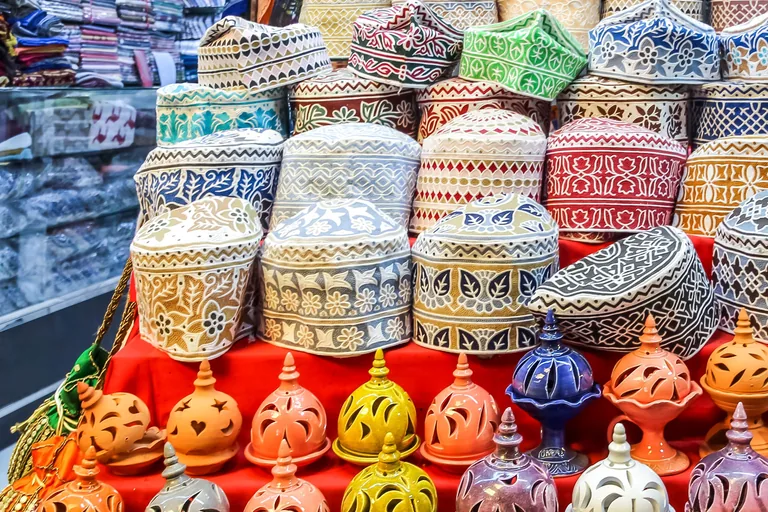
Photo: Dr. Thomas Liptak · Wikimedia Commons source · CC BY-SA 4.0 · Cropped to the recorded 3:2 source rectangle and resized from the exact hash-bound source input. Souq al-Dhalam
Souq al-Dhalam is the local name for the narrow roofed lanes of the Mutrah souq near the shore, and the stop is at a crossing of those lanes under a round roof. The route stops here for what the souq sells: the market cannot be seen from outside and runs deep into the town from a gate facing the sea, and besides silver, khanjars, cloth and copper and clay pots it offers Omani halwa, spices and the vessels in which incense is burned, while in the past its shops were mostly limited to grilled fish, sweets and cloth. The crossing is crowded in the evening and before Ramadan and the Eids, there are steps up into the shops, and hours vary by shop and change in Ramadan, so check locally and ask before photographing anyone.
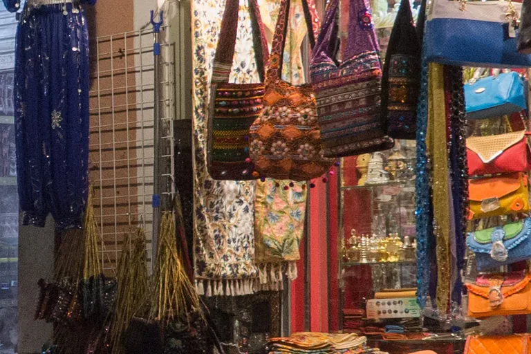
Photo: Juozas Šalna · Wikimedia Commons source · CC BY 2.0 · Cropped to the recorded 3:2 source rectangle and resized from the exact hash-bound source input. Khor Bimba
Khor Bimba is the old hollow that the souq's main covered lane is thought to follow inland, a gentle slope whose shopfronts are set several steps up from the paving. The route stops here for the town that grew around the hollow: in 1908 the British survey recorded a quarter called the Wadi on both sides of it, from the main gate of the town down to the sea, and in the 1960s the souq supplied the people of the interior with goods that came mostly from abroad, while cloth, vegetables, fruit and palm products came down to it from inland. After heavy rain, water can flow down these lanes toward the corniche, so do not walk the souq during a downpour; GPS is weak under the roofs, and many shops close for a break in the early afternoon and on Friday mornings.
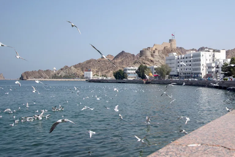
Photo: Mostafameraji · Wikimedia Commons source · CC BY 4.0 · Cropped to the recorded 3:2 source rectangle and resized from the exact hash-bound source input. The souq gate
The souq gate is the main entrance of the Mutrah souq on the corniche, where the covered lanes end in steps above Al Bahri Road and the bay. The route stops here for the trade of this beach: in 1908 some of the Hindu merchants of the town went in person to the Samail valley and inner Oman to buy dates, and the ruler Said bin Sultan ratified in 1835 a treaty with the United States that the American envoy Edmund Roberts had negotiated at Muscat, and later sent a ship of his own to the United States to further trade with it. The stop is on the pavement outside the gate, with steps at the gate and little shade; the walk goes on along the seaside promenade, so cross Al Bahri Road at the marked crossing in front of the gate and take care in the evening traffic.
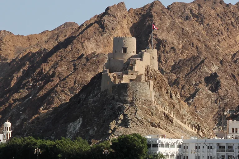
Photo: Eduard Marmet · Wikimedia Commons source · CC BY-SA 2.0 · Cropped to the recorded 3:2 source rectangle and resized from the exact hash-bound source input. Below Mutrah Fort
Mutrah Fort stands on a rocky height above the corniche road at the eastern end of the old town, its round towers set at different heights on the rock. The route stops here for the fort's later uses: a newspaper report of 2017 says it served at times as a prison as well as a stronghold, and that it had reopened after some years of renovation with easier stairways, cannon set along its walls and a dark stair down to a lower chamber thought to have held stores or prisoners, with a view from the top over the harbour, the fish market and the sea road. The stop is on the wide, level and unshaded seaside promenade, with the road between it and the fort; a visit is optional and ticketed, up steep stairs from the landward side, and the marked crossing is back at the souq gate, so cross there rather than opposite the fort, and carry water for the open stretch ahead.
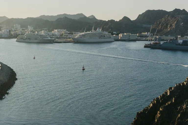
Photo: Alexey Komarov · Wikimedia Commons source · CC BY-SA 4.0 · Cropped to the recorded 3:2 source rectangle and resized from the exact hash-bound source input. The corniche, looking back at the port
This stop is a small paved garden on a rocky point beside the Mutrah promenade, looking back west over the bay to the town and the quays of Port Sultan Qaboos. The route stops here for the bay's past and future: a British political agent's account published in 1919 says the canoes ferrying people between Mutrah and Muscat passed three villages at the mouths of the ravines, Mataira, Riyam and Kalbuh, the corniche today runs for about three kilometres with a fish market and a marina at its northern end, and in 2026 the tourism ministry signed an agreement to make the port's waterfront a district of shops, hotels, homes and a promenade, to be built in three phases. The garden is level, free and open, with benches and no road to cross, but there is almost no shade here or on the promenade on either side, so in the hot months walk this stretch early or late and carry water.
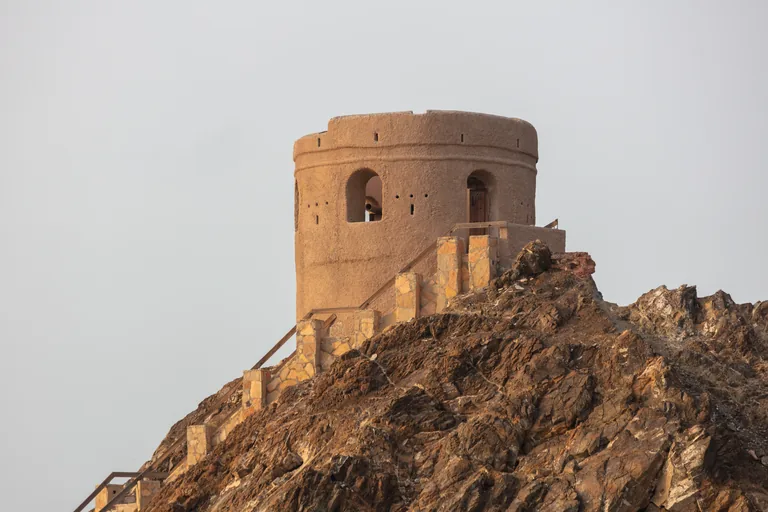
Photo: Diego Delso · Wikimedia Commons source · CC BY-SA 4.0 · Cropped to the recorded 3:2 source rectangle and resized from the exact hash-bound source input. Riyam Park
Riyam Park is a fenced public park beside the coast road at the eastern end of the bay of Mutrah, overlooking the port, below a headland with a modern monument in the form of an incense burner and small watchtowers on its rocks. The route ends here for the shape of that monument and the life of the park: incense burners of the old Arabian kind stand on a square base under a square cup, later ones are often rounded, and the form has even shaped buildings, such as minarets of the Ayyubid period in Egypt, while in 2018 the park, which overlooks the port, held an exhibition of paintings of Omani boats whose proceeds went to charitable work in Mutrah. The stand point is on the level seaside promenade at the road bend, with no shade; the park is fenced and keeps its own hours, the paths up to the monument and the towers are not part of the walk, and the walk ends here, with taxis on the coast road and no return transport at the stop.


Local context
Before you go
The walk covers about three kilometres one way on the level, west to east along the bay, from the fish market on the corniche to Riyam Park, with a short loop through the covered lanes of the souq. Several stops sit beside Al Bahri Road, the busy corniche road, so cross only at marked crossings; east of the souq the corniche is long and open, with almost no shade. The walk ends at Riyam Park, where taxis pass on the coast road.
On the ground
Access and surfaces
About three kilometres on the level, west to east along the bay, with a short loop through the covered lanes of the souq; there are no climbs unless you choose to go up the stairs to Mutrah Fort. Mutrah is hot for much of the year and the corniche east of the souq has almost no shade: carry water, wear a hat and walk early in the morning or in the late afternoon, and in summer avoid the middle of the day. The fish market works in the morning and is usually shut by early afternoon; the stop works from outside at any hour. Many souq shops close for a break in the early afternoon and on Friday mornings, and hours change in Ramadan, so check locally; the lanes are narrow and crowded in the evening and on holidays, and GPS is weak under the roofs, so a souq stop may start a few steps early or late. Several stops sit beside Al Bahri Road, the busy corniche road: cross only at marked crossings. Dress modestly, with shoulders and knees covered, especially in the souq and near the mosques. Sur al-Lawatiya is a private residential quarter: stay on the corniche outside it and do not photograph residents. Bait al Baranda and the fort are optional visits that charge for entry and keep their own hours.
Frequently asked
Plan the walk
- How long is the Muscat audio walking tour?
- Allow about 90 minutes. The route covers 3 km (1.9 mi) one way in 10 stops, including walking and listening time.
- Where does the Muscat tour start and end?
- It starts on the seafront beside the Muttrah Fish Market, at the western end of the corniche, and ends at Riyam Park at the eastern end of the bay. Taxis pass on the coast road at the end, or you can walk back along the promenade.
- Do I need to go inside the museum or the fort?
- No. Every stop works from outside. Bait al Baranda is a museum and Mutrah Fort is reached up steep stairs from the landward side of the corniche road; both are optional visits that charge for entry and keep their own hours, so check locally. Sur al-Lawatiya is a private residential quarter, and the walk stays on the corniche outside it.
- Is there shade on the route?
- Little. The covered lanes of the souq are shaded, but the corniche east of the souq is long and open. Mutrah is hot for much of the year, so start early in the morning or in the late afternoon and carry water.