Marrakech · Marrakech-Safi, Morocco
Marrakech — The Square That Outlived the Palaces
An audio walk through Marrakech, from the booksellers' mosque through the royal kasbah and the Jewish quarter to the storytellers' square.
Narration in English · Stop 1 is free
 Tour no. 36
- Stops
- 10
- Distance
- 3 km (1.9 mi)
- Time
- About 120 minutes
- Route
- Moderate walking route
Listen before you buy
Stop 1 · Koutoubia Mosque
Stop 1 is free. Listen before you buy.
The walk
An audio tour from the Koutoubia through the royal kasbah and the Mellah to the storytellers' square, at your own pace
Marrakech gave its name to the whole country, and it began around 1070 as a camp on an empty plain, laid out by the Almoravids, Berber nomads from the Sahara. The walk starts at the Koutoubia, the mosque named after the booksellers who once worked at its foot, where a man whose name is read as Abd Allah al Jazuli signed the wet plaster inside the minaret in 1165 or 1166. It follows long, high ochre walls south to Bab Agnaou, the carved gate of the walled city the Almohad caliphs built for themselves, whose inscription invites those who come in to enter in peace, and passes the kasbah's own mosque, where the spheres on the minaret, long said to be gold, are copper. A narrow passage beside it leads to the Saadian Tombs, where the sultan Ahmad al Mansur lies in the mausoleum he built for himself, and his mother, Lalla Mas'uda, who built a great mosque and a bridge, lies beside her husband.
Ahmad al Mansur called his palace al Badi, the Incomparable. By the historian al Ifrani's account it took fifteen years to build, and a jester at the feast for the finished palace said that when it was demolished it would make a big heap of earth; early in the eighteenth century Moulay Ismail ordered it stripped, though modern historians think the stripping was gradual. Past the tinsmiths' square the route enters the Mellah, the Jewish quarter the Saadian sultans set beside their palace, and stops at the Lazama synagogue, which tradition dates to 1492 and which is still in use. The Bahia, a vizier's palace, was reportedly looted on the sultan's orders within hours of its owner's death in 1900, and the house his brother built nearby became the national museum of weaving and carpets in 2018. The walk ends at the Jemaa el Fna, the open square of storytellers, food stalls and music, which in 2001 was on UNESCO's first list of Masterpieces of the Oral and Intangible Heritage of Humanity.
Route notes
The stops
About each stop · narration stays in the app
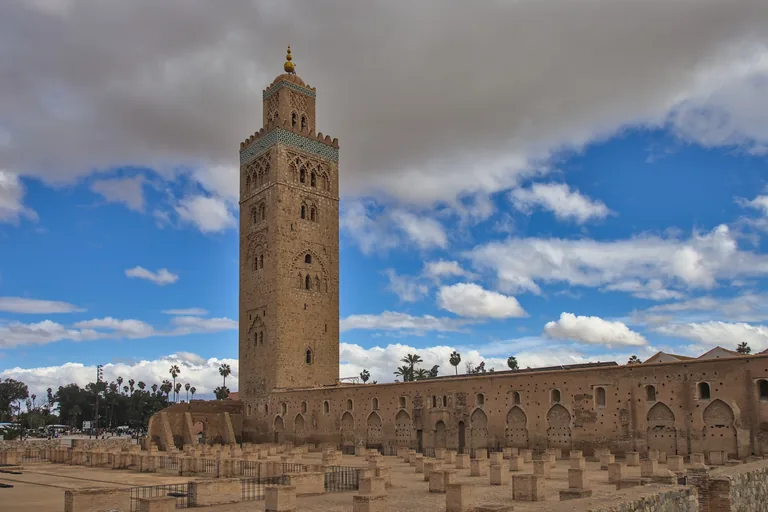
Photo: Draceane · Wikimedia Commons source · CC BY-SA 4.0 · Cropped to the recorded 3:2 source rectangle and resized from the exact hash-bound source input. Koutoubia Mosque
The Koutoubia is the twelfth century Almohad mosque whose square minaret, about 77 metres high, marks the start of the walk; the mosque is named after kutubiyyin, the Arabic word for booksellers, for the book trade once carried on in the street along its eastern side. The route begins here because the ground beside it holds the city's first layers: excavations on the north side of the first Almohad mosque uncovered part of the wall of the Ksar el Hajar, the stone fortress of the city's Almoravid founder, Abu Bakr ibn Umar, and early in the sixteenth century the traveller Leo Africanus wrote that almost a hundred bookshops were said to have stood under its porch, though in his day he thought not one bookseller was left in the city. It is a working mosque, reopened for prayer in March 2024 after repairs that followed the earthquake of September 2023, and only Muslims may go inside, so the stop is made from the paved esplanade and gardens beside it; cross the busy avenue at the lights.
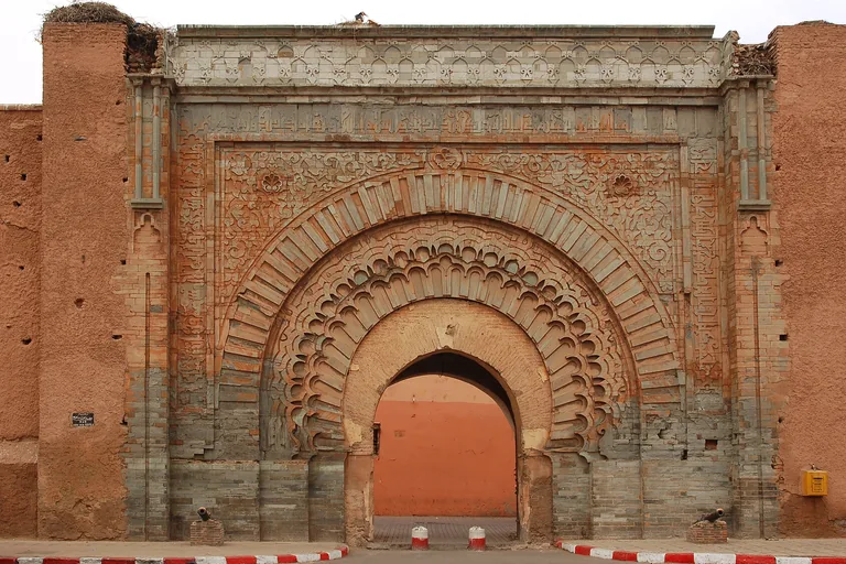
Photo: Luc Viatour · Wikimedia Commons source · CC BY-SA 3.0 · Cropped to the recorded 3:2 source rectangle and resized from the exact hash-bound source input. Bab Agnaou
Bab Agnaou was the main public entrance to the kasbah, the royal district the Almohads built in the south of the medina, and its carved sandstone arch, completed around 1188, is framed by a band of Qur'anic inscription in Kufic script. The route passes through it into that royal quarter, and the gate shows how much has gone: it was once flanked by two towers with a bent passage behind it, but the towers and the vaulted vestibule have disappeared and the arch was later narrowed with a smaller brick one, while early in the sixteenth century Leo Africanus described the kasbah beyond as more like a city than a castle. The gate stands on a busy road with heavy traffic and horse carriages, so keep to the pavement by the wall and use the crossing; the passage through it is narrow and shared with motorbikes.
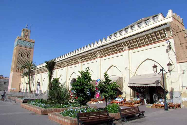
Photo: David Berkowitz from New York, NY, USA · Wikimedia Commons source · CC BY 2.0 · Cropped to the recorded 3:2 source rectangle and resized from the exact hash-bound source input. Kasbah Mosque
The Kasbah Mosque was built for the Almohad caliph Yaqub al Mansur, probably between about 1185 and 1190, as the congregational mosque of the royal district where the ruler himself came to prayers. It is on the route as the kasbah's own mosque and a building that outlived its founders: the Saadian sultan Abdallah al Ghalib restored it after a gunpowder explosion in the sixteenth century, and in 1907 a group led by Madani El Glaoui gathered here to pledge allegiance to Abdelhafid as sultan. It is a working mosque that only Muslims may enter, so the stop is made from the street beside it, which is shared with motorbikes; the three spheres on the minaret's finial, long rumoured to be gold, are copper.
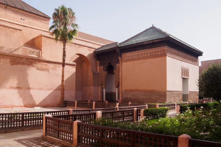
Photo: C messier · Wikimedia Commons source · CC BY-SA 4.0 · Cropped to the recorded 3:2 source rectangle and resized from the exact hash-bound source input. Saadian Tombs
The Saadian Tombs are the burial complex of the Saadian dynasty beside the Kasbah Mosque, built up mainly under the sultan Ahmad al Mansur, who reigned from 1578 to 1603 and was buried in the centre of the mausoleum chamber he had built. The route includes them as the part of the Saadian court that survived: the Alawi sultan Moulay Ismail later closed the tombs off from most of the surrounding buildings, and the American writer Edith Wharton recorded that the French authorities did not know they existed until 1917, when the sultan's government told the Resident General that a treasure of Moroccan art was falling into ruin. They are reached by a very narrow passage beside the mosque and are a ticketed site with their own hours, often with a queue, so the stop is made from the mouth of the passage.
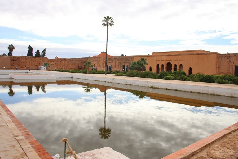
Photo: Draceane · Wikimedia Commons source · CC BY-SA 4.0 · Cropped to the recorded 3:2 source rectangle and resized from the exact hash-bound source input. El Badi Palace
The El Badi Palace is the ruin of the palace the Saadian sultan Ahmad al Mansur began a few months after he came to the throne in 1578, and its name, usually translated as the Incomparable, is drawn from the ninety nine names of God in Islam. It is the walk's clearest case of a palace built lavishly and then taken apart: the historian al Ifrani, citing al Fishtali, records that Italian marble was paid for with its weight in sugar, notes that the sultan provided for his workers' children while they built it, and reports that Moulay Ismail later ordered the palace demolished and stripped, though modern historians think the dismantling was gradual. It is a ticketed site with its own hours whose ruins are wide and unshaded inside, so the stop is made from the lane outside the entrance; the carved twelfth century minbar of the Koutoubia is on display within.
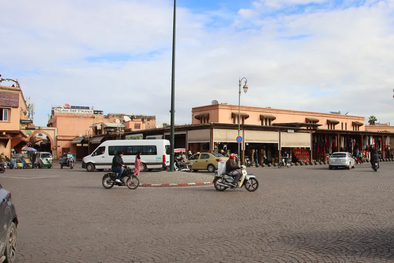
Photo: Draceane · Wikimedia Commons source · CC BY-SA 4.0 · Cropped to the recorded 3:2 source rectangle and resized from the exact hash-bound source input. Place des Ferblantiers
Known in Arabic as Qzadria, the Place des Ferblantiers takes its French name from tinsmiths, and the square, at the junction of the medina and the kasbah, was traditionally a place of metalworkers; Bab Berrima, a gate between the two, stands at its south end. The route crosses it to reach the Mellah, the former Jewish quarter, which opens off the square; around 1900 the British writer Budgett Meakin noted Jewish tinsmiths, carpenters and cobblers working in the streets just outside the quarter. It is an open, partly shaded square with cafés and shops, whose plans under a city renewal programme launched in 2014 included paving, lighting and trees, and horse carriages and tour coaches stop at its edges.
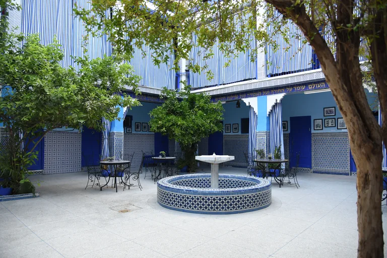
Photo: Yeudameir · Wikimedia Commons source · CC BY-SA 4.0 · Cropped to the recorded 3:2 source rectangle and resized from the exact hash-bound source input. Lazama Synagogue
Slat al Azama, the Lazama synagogue, is a synagogue built into a house around a central courtyard in the Mellah, the Jewish quarter the Saadian sultans established in the sixteenth century, and tradition dates its foundation to 1492, though one scholar notes that the year has not been verified. It is on the route as the place where the quarter's Jewish life continues: the synagogue is still active, although the city's Jewish population, 25,646 in 1936, fell as most of the community left in the decades that followed, and a royal order reported on 31 December 2016 gave instructions for the quarter's lanes and squares to take back their original names. It is an active place of worship in a narrow lane of the Mellah with its own visiting hours, so the stop is made from the lane outside.
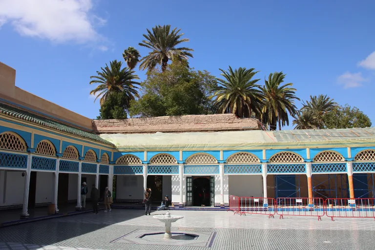
Photo: Draceane · Wikimedia Commons source · CC BY-SA 4.0 · Cropped to the recorded 3:2 source rectangle and resized from the exact hash-bound source input. Bahia Palace
Si Musa, grand vizier to the sultan, started the Bahia Palace in the 1860s, and his son Ba Ahmed, who governed Morocco as grand vizier for the young sultan Abdelaziz, enlarged it between 1894 and 1900. The route stops here for the speed of its fall: the journalist Walter Harris, who had twice dined with Ba Ahmed in the palace, wrote that after the vizier's death the sultan followed his bier in tears, then signed a decree confiscating all his property, and that for days loaded pack animals carried it away. It is a ticketed palace with its own hours and a long garden walk from the gate to the courtyards, often crowded, so the stop is made at the gate on the street.
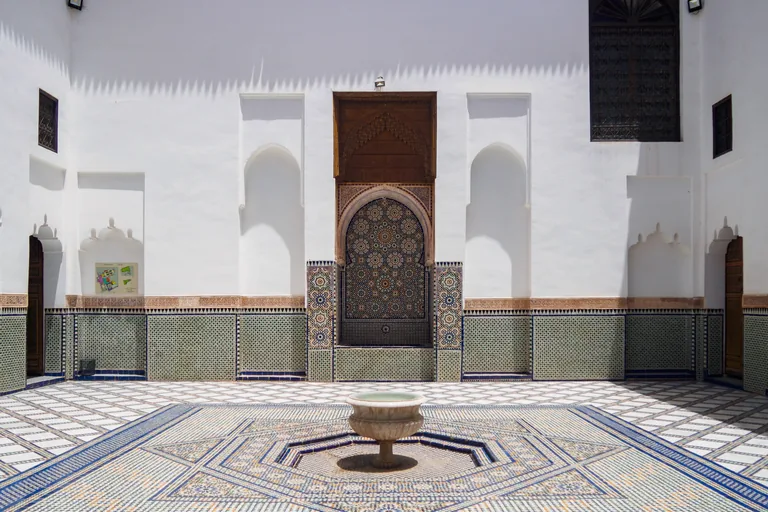
Photo: C messier · Wikimedia Commons source · CC BY-SA 4.0 · Cropped to the recorded 3:2 source rectangle and resized from the exact hash-bound source input. Dar Si Said
Dar Si Said is the late nineteenth century house of Si Said ben Musa, brother of the grand vizier Ba Ahmed and a minister in his government, and in 2018 it became the National Museum of Weaving and Carpets. It is on the route as the family's second house, which took on other lives: after 1914 it was the seat of the region's governors under the French Protectorate, a primary school ran in one wing until 1987, and its first floor housed the beginnings of Marrakech's first radio station. The house was damaged in the earthquake of September 2023, so check the museum's current status before planning a visit inside; the stop itself is made from the narrow lane outside the doorway.
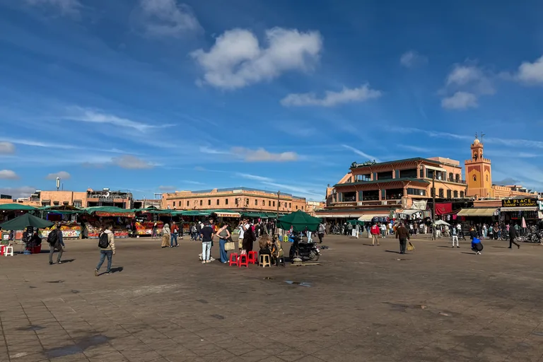
Photo: 瑞丽江的河水 · Wikimedia Commons source · CC BY-SA 4.0 · Cropped to the recorded 3:2 source rectangle and resized from the exact hash-bound source input. Jemaa el-Fnaa
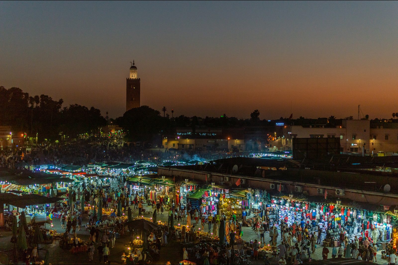
The Jemaa el Fna is the great open square of the medina, where, by UNESCO's description, people come for traditional medicine, fortune telling, preaching and henna painting as well as for performances by storytellers, poets, Berber musicians and Gnaoua dancers. The route ends on it as the city's stage for spoken art, and a Marrakech heritage scholar wrote around 2010 that storytellers, once the square's leading figures, had been pushed to its edges by spreading commerce, and that those still working reshaped tales from old epics and the Thousand and One Nights into new stories for the people gathered around them. It is a very large open square, crowded in the evening with food stalls and smoke and crossed at its edges by motorbikes, so watch your belongings; the Koutoubia minaret, where the walk began, stands over its western side.


.jpg)

.jpg)

.jpg)
.jpg)

.jpg)


Local context
Before you go
The walk covers about three kilometres through the southern half of the medina, mostly on the flat. It starts on the open esplanade beside the Koutoubia Mosque on Avenue Mohammed V and ends at the Jemaa el Fna, within sight of the Koutoubia minaret where it began. The streets are narrow and shared with motorbikes, scooters, hand carts and the occasional donkey or horse carriage; there are few pavements, and the road outside Bab Agnaou carries heavy traffic. Shade is scarce in the middle of the day and the summer heat is severe, so carry water. Unofficial guides may offer to show you the way or tell you a street is closed; a polite no is enough.
On the ground
Access and surfaces
About three kilometres, mostly on the flat, through narrow streets shared with motorbikes, scooters, hand carts and horse carriages, with few pavements; the road outside Bab Agnaou carries heavy traffic. Shade is scarce in the middle of the day and the summer heat is severe, so carry water. Every stop works from the street. The Koutoubia and the Kasbah Mosque are working mosques that only Muslims may enter; the Saadian Tombs, the El Badi Palace and the Bahia Palace charge for entry and keep their own hours, and the synagogue keeps its own visiting hours. The Jemaa el Fna is crowded in the evening, so watch your belongings.
Frequently asked
Plan the walk
- How long is the Marrakech audio walking tour?
- Allow about 120 minutes. The route covers 3 km (1.9 mi) in 10 stops, including walking and listening time.
- Where does the Marrakech tour start and end?
- It starts on the esplanade beside the Koutoubia Mosque on Avenue Mohammed V and ends at the Jemaa el Fna, the big square within sight of the Koutoubia minaret where the walk began.
- Do I need to go inside the mosques, tombs or palaces?
- No. Every stop works from the street. The Koutoubia and the Kasbah Mosque are working mosques that only Muslims may enter, and the Saadian Tombs, the El Badi Palace and the Bahia Palace charge for entry and keep their own hours.
- Is the route shaded?
- Not much. Shade is scarce in the middle of the day and the summer heat is severe, so carry water.
- Will the Marrakech audio tour work offline?
- Yes, after download. Audio, stop text, images, and GPS triggering work without data; the live map background still needs a connection.