Luxor · Luxor Governorate, Egypt
Luxor — The Road of the Gods
An audio walk through Luxor, from the Winter Palace on the Nile past Luxor Temple and the souq, beside the dug out Avenue of Sphinxes to the gate of Karnak.
Narration in English · Stop 1 is free
 Tour no. 40
- Stops
- 10
- Distance
- 3.5 km (2.2 mi)
- Time
- About 95 minutes
- Route
- Easy city route
Listen before you buy
Stop 1 · Winter Palace Hotel
Stop 1 is free. Listen before you buy.
The walk
An audio tour from the Nile past Luxor Temple, the saint's mosque and the souq, beside the Avenue of Sphinxes to the gate of Karnak, at your own pace
More than three thousand years ago a processional road about 2.7 kilometres long joined Karnak to Luxor Temple, and once a year, at the feast of Opet, the statues of Amun, Mut and Khonsu were carried along it. Then the town grew over it. The walk starts on the Nile at the Winter Palace, a hotel that opened in 1907, where Howard Carter used the noticeboard to give out news after he found the tomb of Tutankhamun. It passes Luxor Temple, which the people of Luxor lived in and on for centuries until the rubble stood some fifteen metres high, and where the English writer Lucie Duff Gordon moved into a house on top of the debris in 1864; nearly four years later part of it fell into the temple. High on the temple's court stands the mosque of the saint Abu al Haggag, who died in 1244, the one part of the old town left standing after the clearance.
From the souq, where the dealer Muhammad Mohassib, once a donkey boy for Duff Gordon, sold antiquities to museums in Europe and America, the route comes out beside the sunken avenue and looks back at the obelisk that stayed when its partner went to Paris in the 1830s. It follows the avenue, traced from end to end between 1984 and 2000 and cleared of the houses on top of it from the late 2000s, when, by the reports of the time, more than 800 families were moved, past the precinct of Mut, where from 1895 Margaret Benson, joined by Janet Gourlay in 1896, ran an excavation led entirely by women. It ends at Bab el Amara, the gateway Ptolemy III built in the third century BC, whose opening rises about fourteen metres, in front of the temple of Khonsu, where the outlines of feet cut into the roof turned out to be mostly the work of the temple's own priests.
Route notes
The stops
About each stop · narration stays in the app
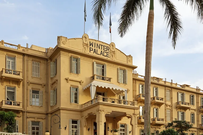
Photo: Marc Ryckaert · Wikimedia Commons source · CC BY-SA 4.0 · Cropped to the recorded 3:2 source rectangle and resized from the exact hash-bound source input. Winter Palace Hotel
The Old Winter Palace is a hotel on the bank of the Nile just south of Luxor Temple, designed by the architect Leon Stienon, built by Benjamin Herbst and inaugurated on 19 January 1907 with a picnic in the Valley of the Kings and then dinner and speeches at the hotel. The walk starts here for the hotel's part in the story of Luxor's visitors: during the war of 1914 to 1918 it took in convalescing soldiers instead of paying guests, the king and queen of the Belgians stayed many times, and in February 1923, as the opening of Tutankhamun's burial chamber drew near, crossing the Nile took twenty minutes and the ride from the tomb to the river was six and a half miles by donkey. The hotel is shut while a restoration runs until its planned reopening in July 2027, so the stop works from the riverside promenade on the river side of the Corniche, with no road to cross.
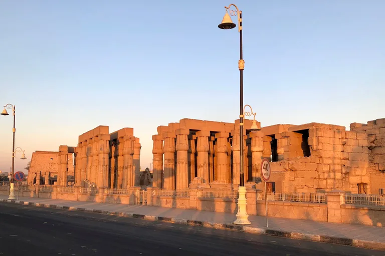
Photo: Marie Thérèse Hébert & Jean Robert Thibault from Québec, Canada · Wikimedia Commons source · CC BY-SA 2.0 · Cropped to the recorded 3:2 source rectangle and resized from the exact hash-bound source input. Luxor Temple
Luxor Temple, in Egyptian ipet resyt, was built from about 1400 BC, with chapels at the rear by Amenhotep III and later parts by Tutankhamun and Ramesses II; in the Roman era it became a legionary fortress with a chapel turned into a church, and it was inscribed on the World Heritage List in 1979. The route stops here for the Colonnade Hall, whose side walls, 24.5 metres long and decorated mostly under Tutankhamun, carry the Opet procession of great boats bringing the gods from Karnak, and for the Epigraphic Survey of the University of Chicago, based at Chicago House in Luxor, whose field season runs from mid October to mid April and whose staff includes photographers, conservators and stonemasons as well as artists and epigraphers. The temple is ticketed, so the stop works from the riverside promenade on the river side of the Corniche road, facing the colonnade across the road.

Photo: Marc Ryckaert · Wikimedia Commons source · CC BY-SA 4.0 · Cropped to the recorded 3:2 source rectangle and resized from the exact hash-bound source input. Abu Haggag Mosque
The Abu Haggag Mosque holds the tomb of Sheikh Yusuf Abu al Haggag under its dome and stands at the north east corner of Ramesses II's court in Luxor Temple; its older minaret, of mud brick and about 14 metres high, rises in three stages, square below and round above. The route stops here for the mosque's people as well as its stones: after faulty wiring in the dome started a fire in 2007, the American Research Center in Egypt documented the building for a year during the repairs, and in recent years the saint's week long moulid has brought tahtib stick players from Sohag, Qena, Luxor and Aswan and horse races in which each family or village fields a horse. It is a working mosque used every day, set high above the public square east of the temple; the stop works from the square, where buses and minibuses use the edge, and the walk does not go up to the mosque.
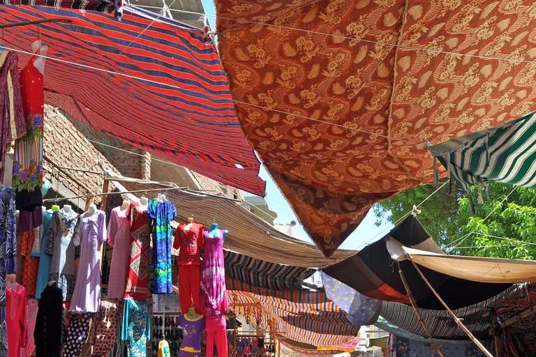
Photo: Marc Ryckaert ( MJJR ) · Wikimedia Commons source · CC BY 3.0 · Cropped to the recorded 3:2 source rectangle and resized from the exact hash-bound source input. Luxor Souq
The souq is Luxor's old market street, a pedestrian lane of shop fronts and awnings that the authorities cleared out in the years before 2010 and gave a new design, public toilets and new cafés, as part of a master plan to make Luxor an open air museum by 2030. The route stops here for the town's long trade with its visitors: the antiquities dealer Muhammad Mohassib, who opened a shop in Luxor in the early 1880s, sold to collectors and museums, among them the travellers Theodore Davis and Emma Andrews and the Museum of Fine Arts in Boston, which bought a head of a king from him in 1904. Motorbikes and handcarts pass through the lane, a nuisance the bazaar owners raised with the tourism minister in November 2021, and goods spill onto the paving, so keep to one side.
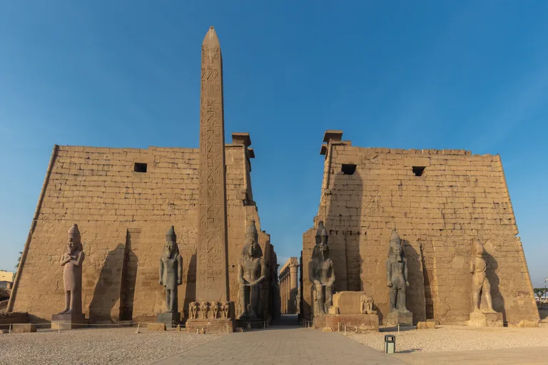
Photo: Diego Delso · Wikimedia Commons source · CC BY-SA 4.0 · Cropped to the recorded 3:2 source rectangle and resized from the exact hash-bound source input. Luxor Obelisk
The Luxor obelisk is one of a pair that Ramesses II set up about 1250 BC before the gateway of Luxor Temple, each cut from a single piece of red granite quarried at Aswan, about 160 kilometres to the south; its east and west faces are slightly convex, as are its partner's, for reasons not understood. The route stops here, about 400 metres up the avenue from the temple, for the view of the gateway and the obelisk that stayed: Champollion chose its partner because that shaft was intact, while his digging showed a great fracture near the base of this one, and the ship Luxor carried the partner to Paris, where it has stood in the Place de la Concorde since 25 October 1836. The avenue and the temple forecourt are ticketed, so the stop works from the public street beside the avenue, looking back south west down it to its temple end.
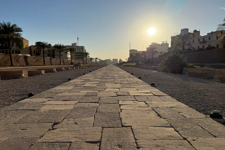
Photo: Chabe01 · Wikimedia Commons source · CC BY-SA 4.0 · Cropped to the recorded 3:2 source rectangle and resized from the exact hash-bound source input. Avenue of Sphinxes
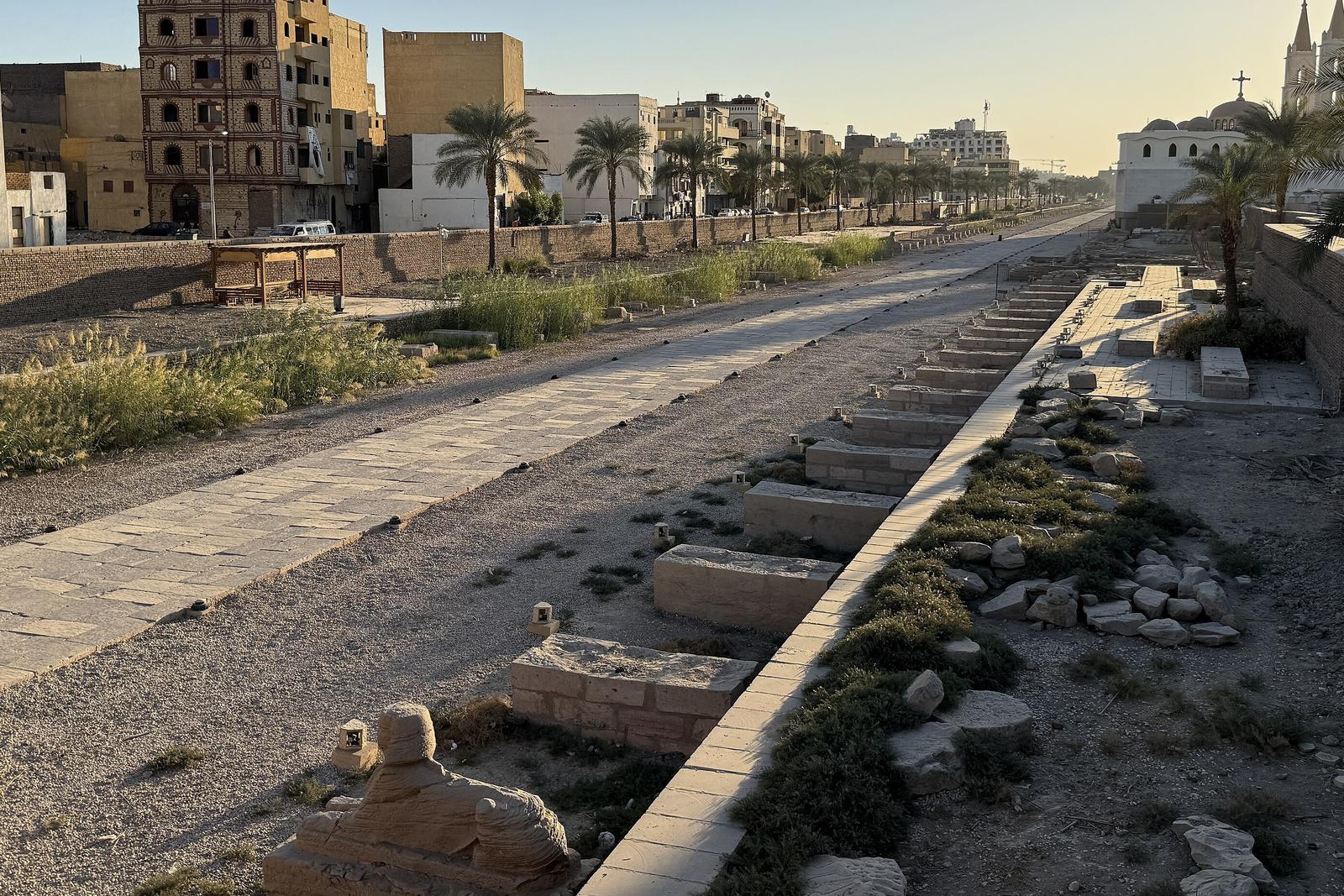
The Avenue of Sphinxes, in Arabic Tariq al Kibash, the road of the rams, runs 2.7 kilometres between Luxor Temple and Karnak; begun in the New Kingdom and completed under Nectanebo I, it lay buried for centuries, and excavators traced its whole route between 1984 and 2000. The route stops here for the long dig that brought it back: the development project began in 2007, stopped in 2011, resumed in 2017 and ran until the avenue opened to the public on 25 November 2021, and on the way the excavators found Roman remains and a fifth century church on an avenue 76 metres wide. The avenue lies below street level behind a wall and is ticketed, so the stop works from the public street beside it, where there is little shade.
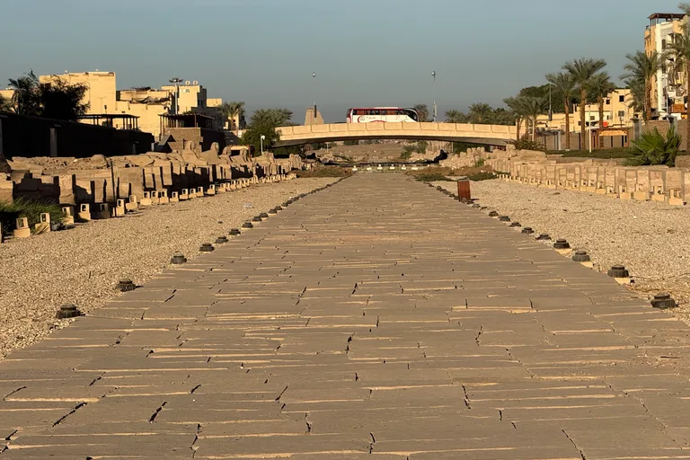
Photo: Chabe01 · Wikimedia Commons source · CC BY-SA 4.0 · Cropped to the recorded 3:2 source rectangle and resized from the exact hash-bound source input. Thutmose Street Bridge
This stop is the quiet lane along the avenue wall just past the north west end of the Thutmose Street road bridge, the walk's one crossing of the Avenue of Sphinxes, with the sunken avenue beside and below. It is where the walk turns to the avenue's last builder, Nectanebo I, whose name means the strong one of his lord: an army general from Sebennytos, he was crowned about 379 BC, saw a Persian invasion fail in the 370s BC with help from the Nile flood, and built and restored on a scale not seen in Egypt for centuries. The bridge has no separate pavement: cross Thutmose Street at the junction at its south east end and walk the 60 metres over it in single file, close to the right hand parapet, then turn right onto the lane.
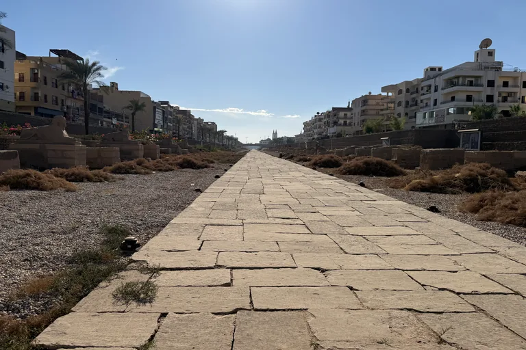
Photo: Chabe01 · Wikimedia Commons source · CC BY-SA 4.0 · Cropped to the recorded 3:2 source rectangle and resized from the exact hash-bound source input. The Opet Road
The Opet Road stop is on the pavement of a busy one way main road beside the avenue, the processional way that joins Karnak, Luxor Temple and the temple of Mut over 2,700 metres of sandstone paving. The route stops here for the feast the road served, in Egyptian heb nefer en Ipet, the beautiful feast of Opet, which is recorded on Hatshepsut's Red Chapel at Karnak, and for the works along the road: round flower basins between Nectanebo's statues watered by small channels, boat docks, a Nilometer and a store for wine jars. Since the reopening on 25 November 2021 the avenue has been ticketed in two halves, so the walk stays on the pavement here and crosses the road only at a gap in the traffic.
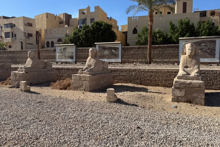
Photo: Chabe01 · Wikimedia Commons source · CC BY-SA 4.0 · Cropped to the recorded 3:2 source rectangle and resized from the exact hash-bound source input. Precinct of Mut
The precinct of Mut lies about 325 metres south of Amun's precinct at Karnak and covers about nine hectares, with a temple to Mut that rulers from Hatshepsut to the Roman emperor Tiberius built and kept up. The route stops here for the people who have dug it since Margaret Benson and Janet Gourlay in the 1890s: the Brooklyn Museum's expedition under Richard Fazzini from 1976, with Farouk Sharid Mohamed as its foreman for nearly four decades and technicians from the village of Quft among its Egyptian crew, and from 2001 a Johns Hopkins team under Betsy Bryan, which found baking and brewing areas and granaries behind the sacred lake. The walk does not go into the precinct, which lies behind the avenue to the south east; this is a roadside stop beside traffic, so stand clear of the carriageway on the avenue side.
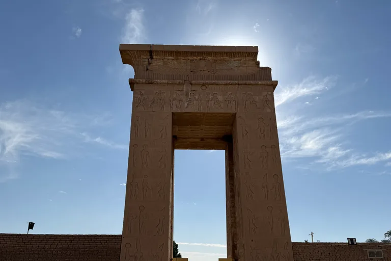
Photo: Chabe01 · Wikimedia Commons source · CC BY-SA 4.0 · Cropped to the recorded 3:2 source rectangle and resized from the exact hash-bound source input. Bab el-Amara Gate
Bab el Amara is the stone gateway that Ptolemy III set in the enclosure wall south of the temple of Khonsu, between two towers, each planned 28.2 metres long, that Nectanebo I or his successor Teos began and never finished; the gate is 21 metres high, and its opening is about 14 metres high and 5.6 metres wide. The walk ends here because the avenue does, at a gate whose inner walls carry the wish for all life, prosperity and health; behind it the American Research Center in Egypt conserved six chapels of the Khonsu temple between 2006 and 2018 and trained 59 conservators from the Ministry of Tourism and Antiquities, and a study of the 334 graffiti on its roof revealed an unknown king of the Twenty second Dynasty named Iny. The gate stands inside the ticketed site of Karnak and the walk ends outside it at a road junction, so stand clear of the carriageway; visitors who want to go in use the main Karnak entrance, reached on foot north around the enclosure.


,_site_du_temple_vu_de_la_Corniche_du_Nil_(49875122048).jpg)


_-_2025-12-04_-_25.jpg)
_-_2025-12-04_-_23.jpg)
_-_2025-12-04_-_20.jpg)
_-_2025-12-04_-_4.jpg)
_-_2025-12-04_-_2.jpg)
Local context
Before you go
The walk covers about three and a half kilometres, flat all the way, from the Corniche on the Nile to the edge of Karnak. It starts in front of the Old Winter Palace Hotel and keeps to public streets and pavements beside the Avenue of Sphinxes, which is fenced and ticketed, so the walk never needs a ticket. It crosses the avenue once, on the Thutmose Street road bridge between Stops 6 and 7, which has no separate pavement, and ends outside Bab el Amara, at the southern edge of Karnak.
On the ground
Access and surfaces
About three and a half kilometres, flat all the way, from the Corniche on the Nile to the edge of Karnak. It follows public streets and pavements; the Avenue of Sphinxes itself is fenced and ticketed, so the walk keeps to the streets beside it and never needs a ticket. There is little shade away from the river. From May to September midday heat is dangerous: walk early in the morning or late in the afternoon, and carry water. The route crosses several busy roads, among them the Corniche and Sharia al Karnak. The walk crosses the Avenue of Sphinxes once, on the Thutmose Street road bridge between Stops 6 and 7. It is the only public way across the avenue on this stretch, and it has no separate pavement: cross Thutmose Street at the junction at the south east end of the bridge, then walk about 60 metres over the bridge beside moving traffic, in single file and close to the right hand (north east) parapet; at the far end turn right onto the lane beside the avenue wall, so there is no second road to cross. There is no way round without traffic; the detour is more than 3 km. Expect offers from carriage drivers and shopkeepers along the Corniche and in the souq. The mosque is narrated from outside; if you visit the mosque, cover shoulders and knees, and women are asked to cover their hair. The temples charge for entry and keep their own hours.
Frequently asked
Plan the walk
- How long is the Luxor audio walking tour?
- Allow about 95 minutes. The route covers 3.5 km (2.2 mi) in 10 stops, including walking and listening time.
- Where does the Luxor tour start and end?
- It starts on the Corniche by the Nile, in front of the Old Winter Palace Hotel, and ends outside Bab el Amara, the stone gateway where the Avenue of Sphinxes meets Karnak.
- Do I need a ticket for the walk?
- No. The avenue is fenced and ticketed, so the walk keeps to the public streets beside it, and every stop works from the street. The temples charge for entry and keep their own hours if you want to visit them afterwards.
- Is the route busy with traffic?
- In places. It crosses several busy roads, among them the Corniche and Sharia al Karnak, and it crosses the avenue once on the Thutmose Street road bridge, which has no separate pavement, so walk the 60 metres over it in single file close to the right hand parapet. There is little shade away from the river: from May to September walk early or late and carry water.
- Will the Luxor audio tour work offline?
- Yes, after download. Audio, stop text, images, and GPS triggering work without data; the live map background still needs a connection.