La Laguna · Canary Islands, Spain
La Laguna — The Town Without Walls
An audio walk through La Laguna on Tenerife, a town laid out by design next to a lake now gone, from the Adelantado's square to the cathedral.
Narration in English · Stop 1 is free
 Tour no. 47
- Stops
- 10
- Distance
- 3 km (1.9 mi)
- Time
- About 95 minutes
- Route
- Easy city route
Listen before you buy
Stop 1 · Plaza del Adelantado
Stop 1 is free. Listen before you buy.
The walk
An audio walking tour of La Laguna on Tenerife from the Plaza del Adelantado out to the old lake's edge, along Calle San Agustín to La Concepción and back down La Carrera to the cathedral, at your own pace
San Cristóbal de La Laguna, on Tenerife, was founded in the years 1496 to 1497, at the end of the conquest of the island, by Alonso Fernández de Lugo, the governor the Crown later named Adelantado, on an upland plain next to a shallow lake. For two centuries it ruled the island; then during the eighteenth century the capital and the trade passed to Santa Cruz, and the old streets kept their shape. The walk begins in the square that carries the Adelantado's title, passes the enclosed convent where Sor María de Jesús, the Siervita, lived for more than sixty years, and goes out to the Plaza del Cristo at the old edge of the town, where the lake lay until army engineers drained it in 1837 and where, by the usual dating, a battle of the conquest was fought in November 1494. Across that square the town buys its food in a market hall that has stood there provisionally since 2007.
From there the route follows Calle San Agustín, once the calle Real, past the house a Genoese family began in 1593, Casa Salazar and the house that is again the seat of the Royal Economic Society, founded in 1777, and the Augustinian convent where friars' students took degrees from 1701 and the Instituto de Canarias has taught since 1846, beside the walls of a church burnt in 1964. It reaches La Concepción, the island's mother parish, in the Upper Town, where the settlers of the conquest built round the church without a plan, then comes back along La Carrera, the main street of the Lower Town laid out to a plan in 1502, past the Teatro Leal to the cathedral, rebuilt from 1904 to 1915 behind a front of about 1820 and a cathedral since the diocese was created in 1819. UNESCO inscribed the town on the World Heritage List in 1999 as “the first non-fortified Spanish colonial town, and its layout provided the model for many colonial towns in the Americas”.
Route notes
Route and itinerary
About each stop · narration stays in the app
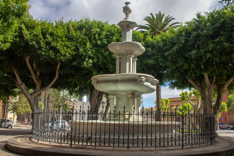
Photo: Mike Peel · Wikimedia Commons source · CC BY-SA 4.0 · Cropped to the recorded 3:2 source rectangle and resized from the exact hash-bound source input. Plaza del Adelantado
The Plaza del Adelantado is the square at the heart of the old town of San Cristóbal de La Laguna, with the town hall, the municipal courts and the small hermitage of San Miguel around it and a marble fountain among trees in the middle. The route starts here because the square has kept its size over the centuries while its look has changed, and because the hermitage across the street, protected as a monument, is thought to have had its front brought forward toward the square when it was enlarged in the eighteenth century. The walk begins about five minutes on foot from Trinidad, the La Laguna end of tram line 1 from Santa Cruz, and cars and vans use the streets round the square, so cross with care.
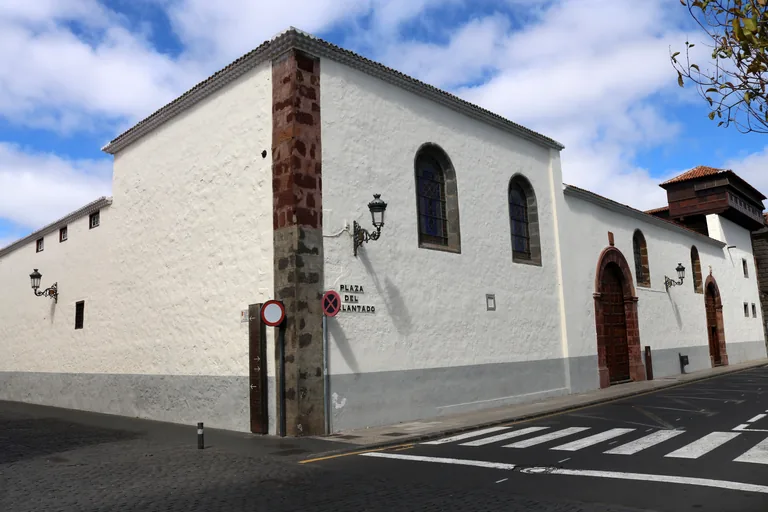
Photo: Maesi64 · Wikimedia Commons source · CC0 1.0 · Cropped to the recorded 3:2 source rectangle and resized from the exact hash-bound source input. Santa Catalina Convent
The convent of Santa Catalina de Siena is the enclosed house of Dominican nuns at the north west corner of the Plaza del Adelantado, behind long whitewashed walls with a carved wooden lookout at the corner of the roof. The route stops here for what those plain walls hold back: the convent was rich until the sales of church property in the nineteenth century stripped much of its wealth, its carved lookouts and tiled roof show Mudéjar influence, and the Palacio de Nava on the same corner of the square, begun in 1585, was refaced entirely in stone by Tomás de Nava in 1776. The convent is enclosed and does not take visitors, so the stop works from the street outside, which carries traffic round the square.
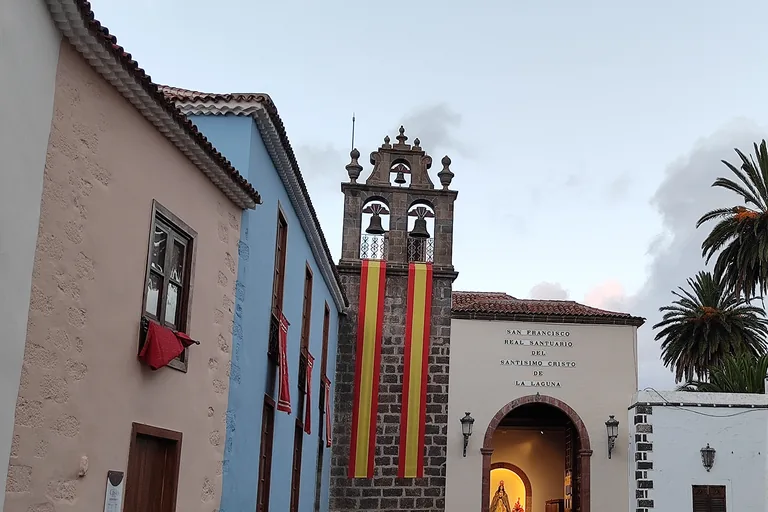
Photo: Mentxuwiki · Wikimedia Commons source · CC BY-SA 4.0 · Cropped to the recorded 3:2 source rectangle and resized from the exact hash-bound source input. Plaza del Cristo and the Santuario
The Plaza del Cristo, long called the Plaza de San Francisco after the Franciscan convent that stood on it, is the wide square at the northern edge of the old town, with the sanctuary of the Cristo at its north east corner. The route stops here at the old edge of the town: until recently the square marked the line between the town and the farmland of the vega behind it, it served until the twentieth century as the drill ground of the barracks that has stood since early in that century on the site of the old convent, and in the great storm of 1826 the lake on this plain overflowed and flooded the town. The walk stays outside the sanctuary and the barracks gate, and the market and the barracks bring cars and vans to the edge of the square, so watch for traffic.
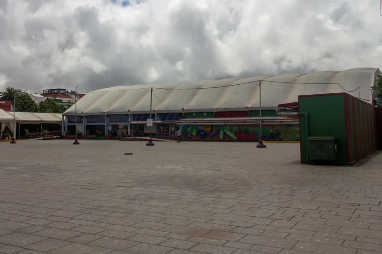
Photo: Mike Peel (www.mikepeel.net) · Wikimedia Commons source · CC BY-SA 4.0 · Cropped to the recorded 3:2 source rectangle and resized from the exact hash-bound source input. The Municipal Market
The municipal market of La Laguna trades in a long, low hall under pale tent roofs on the west side of the Plaza del Cristo. The route stops here because the market stands in this square only provisionally, while it waits for a new building on its old site by the Plaza del Adelantado, and because the farmland of the vega, whose soils the drained lake left good for crops, begins just beyond this side of the town. No market days or opening hours are given here, so check locally, and expect delivery vans at the edge of the square.
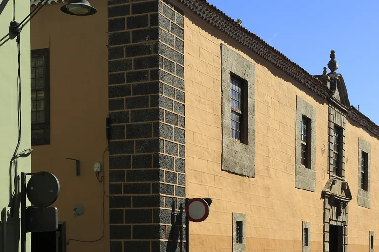
Photo: Falk2 · Wikimedia Commons source · CC BY-SA 4.0 · Cropped to the recorded 3:2 source rectangle and resized from the exact hash-bound source input. Casa Lercaro on Calle San Agustín
Casa Lercaro is the great house from the end of the sixteenth century on Calle San Agustín, the street once called the calle Real, and it now holds the history museum of Tenerife. The route stops here for the street of the merchants' houses, which runs parallel to La Carrera and was made a pedestrian street in works finished in 2011, and for the Casa de Montañés next door, built in 1746 as a private house and now the seat of the advisory council of the Canary Islands. The museum keeps its own hours, so check locally; the street is paved and pedestrian, but delivery vans and bicycles still use it.
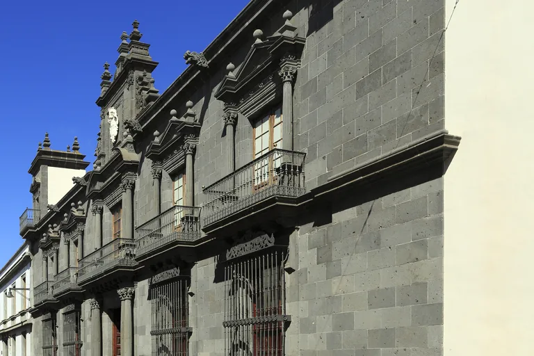
Photo: Falk2 · Wikimedia Commons source · CC BY-SA 4.0 · Cropped to the recorded 3:2 source rectangle and resized from the exact hash-bound source input. Casa Salazar and the Jesuits' House
Casa Salazar is the seventeenth century palace of dark grey stone on Calle San Agustín that has belonged to the bishopric of Tenerife since 1891, and across the street stands the house the Jesuits built in 1733. The route stops here for the families and the learning behind the two fronts: Casa Salazar was begun by Cristóbal Salazar de Frías, who had come to Tenerife at the end of the sixteenth century, carried on by his son and finished by his grandson, who became Count of the Valle de Salazar, while the Royal Economic Society, at home in the Jesuits' house from 1778 and back there since 1959, keeps a library whose French collection of the Nava family runs to more than five thousand works. Both houses are working seats, of the bishop and of the society, so the stop works from the street.
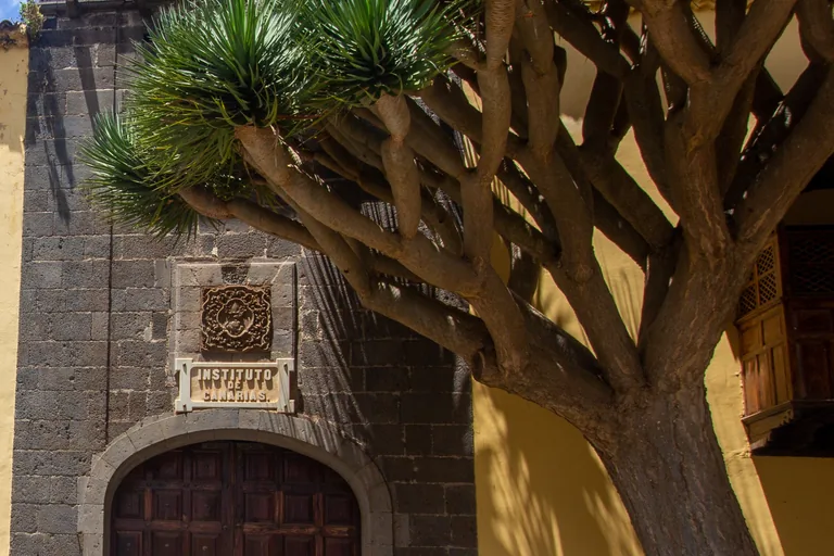
Photo: Mike Peel (www.mikepeel.net) · Wikimedia Commons source · CC BY-SA 4.0 · Cropped to the recorded 3:2 source rectangle and resized from the exact hash-bound source input. San Agustín
The old Augustinian convent on Calle San Agustín has housed the Instituto de Canarias, now the Instituto Canarias Cabrera Pinto, since 1846, beside the roofless walls of its burnt church. The route stops here for the school the convent became: Miguel de Unamuno called it a corner of rare calm that invites study, its old building keeps rooms of natural history, anthropology and scientific instruments, and among its pupils was the painter Óscar Domínguez. The walk stays outside the ruins of the church, which may be fenced or behind hoardings, and outside the school, which is a working public school.
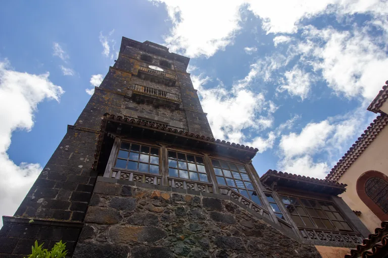
Photo: Mike Peel (www.mikepeel.net) · Wikimedia Commons source · CC BY-SA 4.0 · Cropped to the recorded 3:2 source rectangle and resized from the exact hash-bound source input. La Concepción
La Concepción is the mother parish of La Laguna and of Tenerife, set up in 1497, at the western end of La Carrera in what ICOMOS calls the Upper Town, the part of the town that grew without a plan. The route stops here for the church's later lives: ICOMOS found its present form a mixture of styles left by centuries of changes, among them work in the eighteenth century by the architect Diego Nicolás Eduardo. The walk stays outside the church, the square before it is small and paved, and the tower is sometimes open to climb, so check locally.
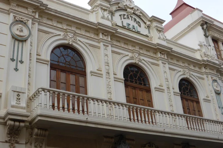
Photo: CARLOS TEIXIDOR CADENAS · Wikimedia Commons source · CC BY-SA 4.0 · Cropped to the recorded 3:2 source rectangle and resized from the exact hash-bound source input. La Carrera at the Teatro Leal
La Carrera, whose official name is Calle Obispo Rey Redondo, is the main street of the planned Lower Town, and the Teatro Leal stands on its north side. The route stops here for the theatre's ups and downs: it opened in September 1915 with the Fiesta de las Hespérides, it even served at times as a ring for Canarian wrestling, a moneylender who later owned it thought of pulling it down, and after it closed in 1990 over problems with its roof it reopened with a concert in September 2008. La Carrera is pedestrian, but delivery vans and bicycles use it, and the theatre keeps its own programme and box office times, so check locally.
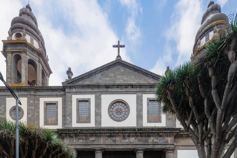
Photo: Fernando · Wikimedia Commons source · CC BY-SA 4.0 · Cropped to the recorded 3:2 source rectangle and resized from the exact hash-bound source input. The Cathedral
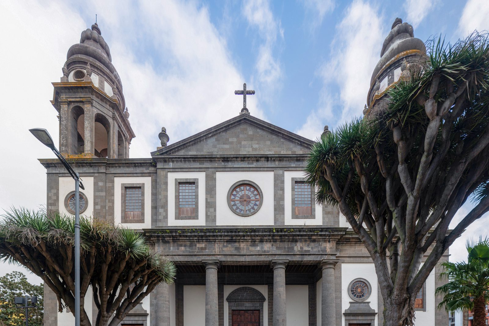
The Cathedral of La Laguna, dedicated to Our Lady of Los Remedios, stands on its own square off La Carrera behind a neoclassical front of about 1820. The route ends here for the church the planned town built and rebuilt: its front is said to follow the cathedral of Pamplona, the vaults and dome taken down from 2009 were rebuilt in concrete with polypropylene fibres, and when the square was relaid in 2014 remains came to light that may belong to the old church of Los Remedios or to the town's early European settlement. Visits inside are ticketed and their times change, so check locally; the walk ends here, a few minutes on foot north of the Trinidad tram stop.


Local context
Before you go
The walk is a loop of about 3 km on foot, mostly level on stone paving and setts, from the Plaza del Adelantado north to the Plaza del Cristo, west along Calle San Agustín to La Concepción and back east along La Carrera to the cathedral square. It begins and ends a few minutes on foot from Trinidad, the La Laguna end of tram line 1 from Santa Cruz.
On the ground
Access and surfaces
A loop of about 3 km on foot, mostly level, with a gentle rise of a few metres toward La Concepción; allow an hour and a half or a little more with the audio. Most of the old town's streets are pedestrian, paved with stone slabs and setts, some uneven and slippery when wet, and delivery vans and bicycles still use them; the walk crosses streets with traffic near the tram stop, round the Plaza del Adelantado and at the edge of the Plaza del Cristo. La Laguna stands at about 550 metres and is cooler, cloudier and wetter than the coast, so bring a layer and something against the rain. The walk stays outside every church and convent; the Santa Catalina convent is enclosed and does not take visitors. If you go into a church, go outside the times of mass, keep your voice down, cover your shoulders and do not photograph people at prayer. Visits inside the cathedral are ticketed and their times change, many shops close in the early afternoon and on Sundays, and some museums close one day a week, so check locally.
Frequently asked
Plan the walk
- How long is the La Laguna audio walking tour?
- Allow about 95 minutes. The route covers 3 km (1.9 mi) in 10 stops, including walking and listening time and the short walks from and back to the Trinidad tram stop.
- Where does the La Laguna tour start and end?
- It starts in the Plaza del Adelantado, about five minutes on foot from Trinidad, the La Laguna end of tram line 1 from Santa Cruz, and ends in the cathedral square, a few minutes on foot from the same tram stop.
- Can I go inside the churches and the convent?
- The walk stays outside every church and convent, and each stop works from the street or square. The Santa Catalina convent is enclosed and does not take visitors. Visits inside the cathedral are ticketed and their times change, so check locally; if you go into any church, go outside the times of mass and cover your shoulders.
- What weather should I expect in La Laguna?
- The town stands at about 550 metres and is cooler, cloudier and wetter than the coast. Mist and sudden rain are common, and the stone paving can be slippery when wet, so bring a layer and something against the rain.