Jerash · Jerash Governorate, Jordan
Jerash — A Roman City and Its People
An audio walk through ancient Gerasa, from the arch raised for Hadrian's visit through the South Gate and the Oval Plaza and up the colonnaded street to the churches, the temple of Artemis and the North Theatre.
Narration in English · Stop 1 is free
 Tour no. 43
- Stops
- 11
- Distance
- 2.5 km (1.6 mi)
- Time
- About 150 minutes
- Route
- Moderate walking route
Listen before you buy
Stop 1 · Hadrian's Arch
Stop 1 is free. Listen before you buy.
The walk
An audio tour from Hadrian's Arch through the South Gate and the Oval Plaza, up the colonnaded street past the churches and the temple of Artemis to the North Theatre, at your own pace
Jerash was Gerasa, one of the self governing Greek cities of the Decapolis, and under Roman rule its own citizens paid for many of the buildings that still stand. The walk sets out at the arch the city raised for the winter stay of the emperor Hadrian, paid for under the will of a citizen named Flavius Agrippa, and the legend that Alexander the Great founded Gerasa is told as the city's own story, which the archaeology does not bear out. It passes the hippodrome, where potters and tanners worked and lived in the rooms beneath the seats long after the racing stopped, goes in through the South Gate and climbs to the sanctuary of Zeus, where a keystone found in 2014 carries a short Greek verse crowning a donor called Demetrios, and to the theatre beside it.
Below lies the Oval Plaza, a curved paved square whose purpose is still argued over, and from it the colonnaded street leads past the market hall and the Umayyad mosque, in a shop beside which a shopkeeper's list of small debts turned up written on a slab of marble; the earthquake of 749 brought the town heavy damage and then a long decline rather than a sudden end. A stair climbs to the cathedral and the church of St Theodore, whose door poem names a priest called Aineias as its giver; the walk goes on by the Nymphaeum, the city's great public fountain, to the sanctuary of Artemis, patron goddess of Gerasa, whose temple later probably became a reception hall and then a fortified house, and to the Three Churches, where a couple named Theodoros and Georgia were portrayed in the floor mosaic of the northern church. It ends at the North Theatre, where seats were set aside for the city's tribes, its linen workers and its Council, with the Circassian families who settled Jerash in the 1880s and the festival held in the old city since 1981 closing the story; the way back is down the colonnaded street, through the South Gate to the arch.
Route notes
The stops
About each stop · narration stays in the app
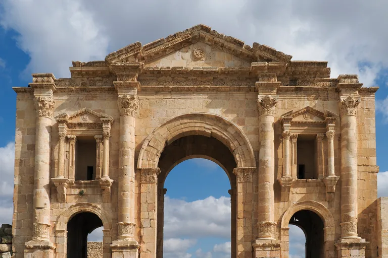
Photo: Petar Milošević · Wikimedia Commons source · CC BY-SA 4.0 · Cropped to the recorded 3:2 source rectangle and resized from the exact hash-bound source input. Hadrian's Arch
Hadrian's Arch is the triple gateway that stands on its own outside the walls of ancient Gerasa, beside the modern road into Jerash, raised in honour of the emperor Hadrian's stay in the city through the winter of 129 and 130. The route starts here for the details a passing glance misses: the base of each of its columns is topped by a row of carved acanthus leaves, a feature that may be Nabataean, and the site's official pages say that soon after its Greek inscription was cut, the city's titles of sacred, asylum and independent were erased, probably on the emperor's order. The stop works from the open ground on the arch's north side, by the car park, where steps and low walls surround the arch, the ground is uneven and there is no shade.
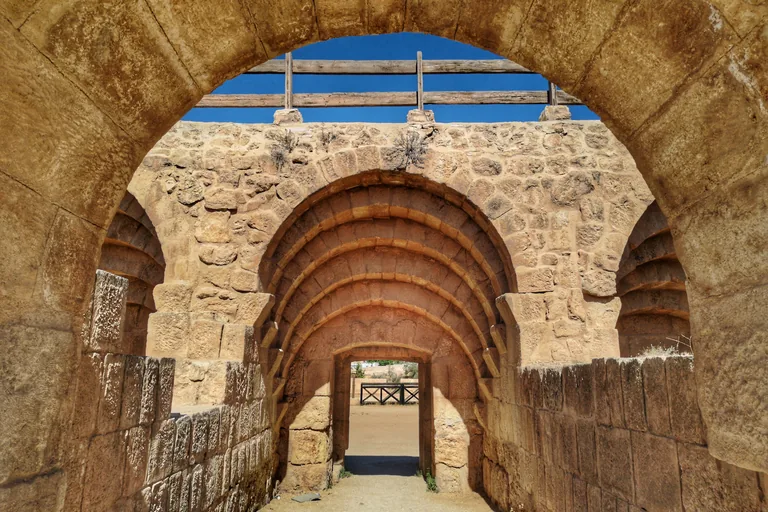
Photo: John Romano D'Orazio · Wikimedia Commons source · CC BY-SA 4.0 · Cropped to the recorded 3:2 source rectangle and resized from the exact hash-bound source input. The Hippodrome
The hippodrome is the walled Roman racecourse between Hadrian's Arch and the South Gate, built in the second century over ground that had been a cemetery, with its arched starting gates for the horses. The route stops here for the building's long working life: from 1984 until his death in 1996 the architect Antoni Ostrasz directed its excavation and restored its south east part, and the site's official pages record that potters later settled in its abandoned south part, and that between the sixth and eighth centuries its stones were quarried to repair the city wall. The stop is told from the walkway along the east side of the arena, outside the city walls, on flat packed earth and gravel with no shade; the walk does not go down into the arena.
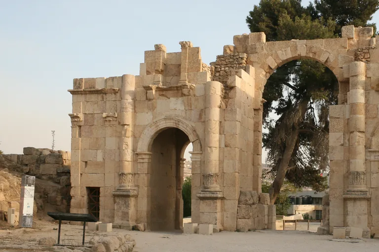
Photo: Diego Delso · Wikimedia Commons source · CC BY-SA 3.0 · Cropped to the recorded 3:2 source rectangle and resized from the exact hash-bound source input. The South Gate
The South Gate is the entrance in the city wall between the hippodrome and the Oval Plaza, one of the four gates of ancient Gerasa, with three arched passages and the widest of them in the middle. The route stops here at the threshold of the walled city: above the two side passages sit inwardly recessed windows framed by capitals, and of the city's gates the North, South and East Gates survive well, the East Gate having been walled up soon after it was built. The stand point is on the walkway between the Visitor Centre and the gate; passing through the gate into the ancient city needs the site ticket, and the paving inside is uneven.
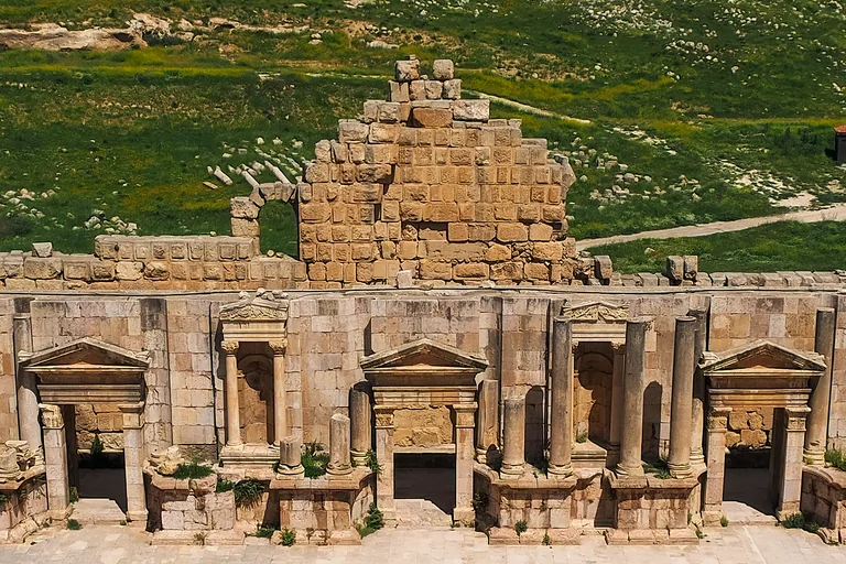
Photo: Petar Milošević · Wikimedia Commons source · CC BY-SA 4.0 · Cropped to the recorded 3:2 source rectangle and resized from the exact hash-bound source input. The Temple of Zeus and the South Theatre
This stop takes in the sanctuary of Zeus on its hill above the Oval Plaza, a lower terrace halfway up the slope with the temple on the summit, and beside it the South Theatre, built between 80 and 96 AD into the slope. The route stops here for the people and skills behind the buildings: the lower terrace keeps at its centre the remains of the cave and the high place where worship began, the keystone found in 2014 is shaped like a huge square headed nail, the excavators uncovered a workshop for casting large bronzes in the sanctuary in 1993 and 2012, and parts of the theatre's stage backdrop of Corinthian columns were still visible early in the nineteenth century. The hill is reached by steep paths and steps from the plaza, with loose stone and uneven ground on top; the theatre's seats are steep and without handrails in places, and there is no shade.
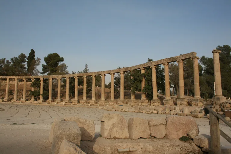
Photo: Diego Delso · Wikimedia Commons source · CC BY-SA 3.0 · Cropped to the recorded 3:2 source rectangle and resized from the exact hash-bound source input. The Oval Plaza
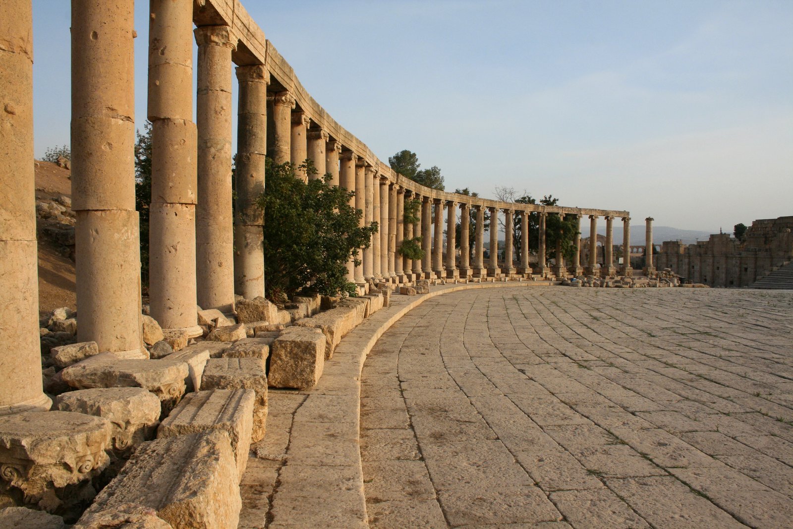
The Oval Plaza, also called Symposium Square, is the paved square ringed by Ionic columns at the foot of the sanctuary of Zeus, where the colonnaded street sets off north. The route stops here for the city's growth and what it left behind: the site's official pages think it likely that the stretch of street from the square to the northern crossroads originally had Ionic columns, later replaced by Corinthian ones, and on Camp Hill just east of the street, looking over the plaza, the small Jerash Archaeological Museum shows finds from the site, among them small statues identified as the Muses, found in 2016, and a lead sarcophagus of the late fourth to fifth century. The plaza floor is old stone paving, level but worn and uneven in places, with no shade; during the Jerash Festival in summer it may be set up for events.
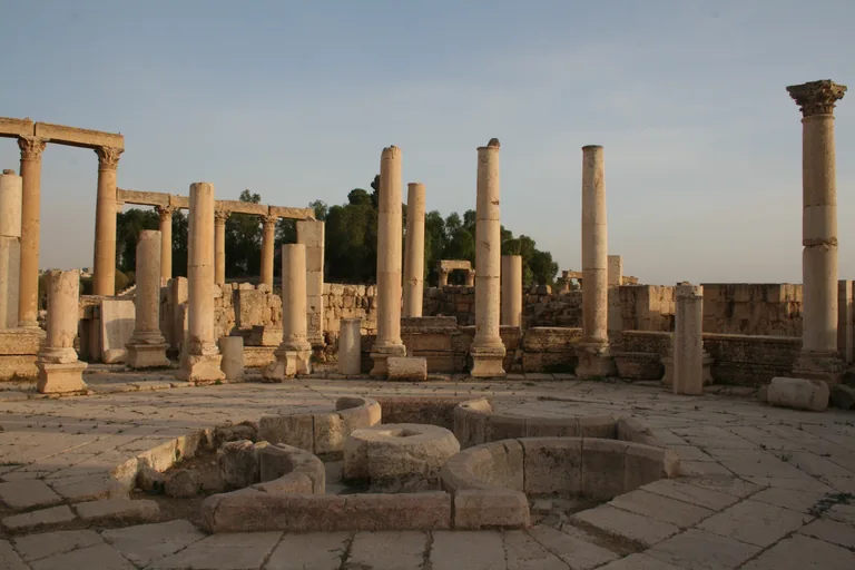
Photo: Diego Delso · Wikimedia Commons source · CC BY-SA 3.0 · Cropped to the recorded 3:2 source rectangle and resized from the exact hash-bound source input. The Colonnaded Street, the Market Hall and the Umayyad Mosque
This stop is the stretch of the colonnaded street north of the Oval Plaza, with the Roman market hall beside it, the crossroads of the South Tetrapylon ahead and the excavated eighth century mosque behind a row of shops. The route stops here for the town's trade across the centuries: the market hall filled a whole block between the plaza and the crossroads, its stalls set in niches alternately rectangular and semicircular, and its ruins were probably lived in again in the Abbasid period, while in the shops against the mosque the excavators found back rooms divided by low storage bins, one holding five whole Umayyad pots, and a hearth of mud and red clay strengthened with pieces of broken pottery. The street is original Roman paving, worn smooth in places, uneven where slabs have sunk or lifted and slippery when wet, with no shade; the market hall and the mosque are seen from the street.
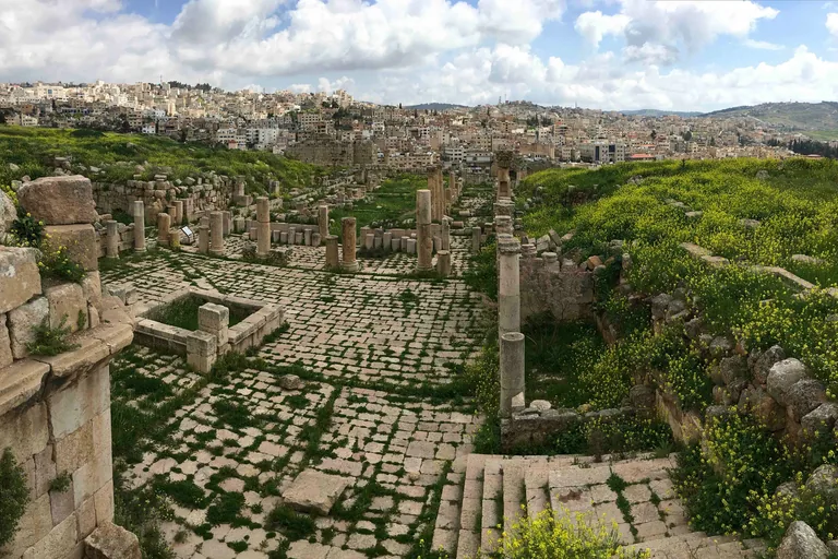
Photo: IGEO map · Wikimedia Commons source · CC BY-SA 4.0 · Cropped to the recorded 3:2 source rectangle and resized from the exact hash-bound source input. The Cathedral Stair, the Fountain Court and the Church of St Theodore
This stop climbs the stair from the colonnaded street to the church called the cathedral, the Fountain Court onto which its main door opens on the west, and across the court the church of St Theodore. The route stops here for the long use of the complex: besides its main door the cathedral had eight other entrances, holes in its columns and walls may once have held plaster panels and bronze fittings, the poem over the west door of St Theodore's forecourt was copied by the French traveller Jules Bertou and published in 1837, and the whole complex declined in the later sixth and seventh centuries until it was abandoned. The stop starts with a long, steep stone stair up from the street with no verified handrail and goes on over uneven old paving and loose stones to the court; no step free route has been verified, there is little shade, and the walk returns down the same stair.
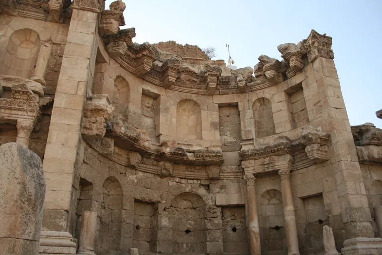
Photo: Diego Delso · Wikimedia Commons source · CC BY-SA 3.0 · Cropped to the recorded 3:2 source rectangle and resized from the exact hash-bound source input. The Nymphaeum
The Nymphaeum is the city's monumental public fountain beside the colonnaded street, a curved recess in two storeys between two side wings, built late in the second century. The route stops here for the water behind it: a supply system was built around 125, the river ran all year, and a spring inside the city, Ain Karawan, was given a monumental setting in the second century and fed the gardens on the east bank and then the East Baths built in their place, while in Christian times the word nymphaeum was also used for the fountains in church forecourts. The fountain is seen from the level main street, on uneven Roman paving with no steps needed and no shade on the street.
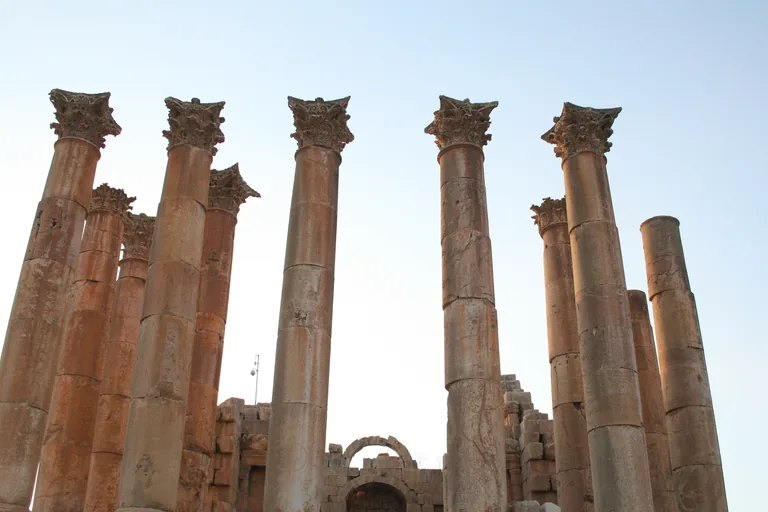
Photo: Diego Delso · Wikimedia Commons source · CC BY-SA 3.0 · Cropped to the recorded 3:2 source rectangle and resized from the exact hash-bound source input. The Sanctuary of Artemis
The Sanctuary of Artemis is the precinct of the city's patron goddess, entered from the colonnaded street, with her unfinished temple standing on a high podium over vaults at the top of its stairs. The route stops here for the way worshippers came up and what has happened since: from gateway columns on the street a stair led to a lower U shaped terrace, and a second stair crowned by a colonnade led to the upper terrace, with porticoes on four sides and a tower altar before the temple; an Italian team has worked in the sanctuary since 1977, and after signs of structural weakness the temple has been partly closed to the public. The terrace is reached from the street through the gateway and up long flights of uneven, worn stone stairs with no verified step free route; the upper terrace is open, rough and unshaded, parts of the temple may be closed or fenced for conservation, and the vaults are not open to visitors.
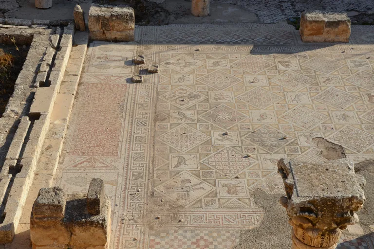
Photo: Carole Raddato from Frankfurt, Germany · Wikimedia Commons source · CC BY-SA 2.0 · Cropped to the recorded 3:2 source rectangle and resized from the exact hash-bound source input. The Three Churches
The Three Churches are the churches of Saint George, Saint John the Baptist and Saints Cosmas and Damian, completed side by side between 529 and 533 to the south west of the temple of Artemis and sharing a porch along their west walls. The route stops here for the people named in the floors: three churches side by side are very uncommon in the Roman province of Arabia, the nave of Cosmas and Damian names the donors Ioannes son of Astrikios and Kalloionistos, its mosaic shows a peacock, a hen and ducks, a hare, a deer and a lamb, Theodoros, who paid for Saint John's, was raised by a man named Thomas, and Jordan's Department of Antiquities restored the west part and the porch in 1979. This is a short spur off the main route on a rough track with loose stones and no verified step free route; the mosaic floors are seen from the edges of the churches, may be covered or roped off to protect them, and are not to be walked on.
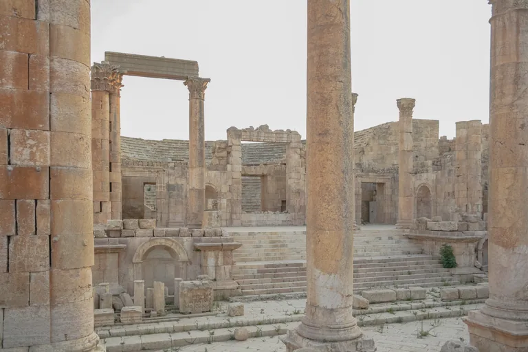
Photo: Diego Delso · Wikimedia Commons source · CC BY-SA 3.0 · Cropped to the recorded 3:2 source rectangle and resized from the exact hash-bound source input. The North Theatre and the North Tetrapylon
The North Theatre is the smaller theatre in the northern part of the ancient city, built into the hillside on a street that runs west from the colonnaded street at the North Tetrapylon, and entered from a rectangular courtyard lined with galleries of Corinthian columns. The route ends here for a street whose colonnades were probably built from older stone: the Ionic colonnades along the street that runs from the theatre were most likely made from stones of the colonnades of the central part of the main street, taken down when it was widened in the second half of the second century, and near the theatre the street's cambered surface and paving stones are still well intact. The stop is at the top of the seating, reached by an uneven hillside path, with steep stone seats without handrails and no shade; the way out is back at the south end, the whole length of the colonnaded street on uneven paving, so keep time and water for it, and while the Jerash Festival runs each summer the theatre may be set up for performances or closed.


Local context
Before you go
The walk covers about two and a half kilometres one way, from Hadrian's Arch outside the walls of the ancient city north to the North Theatre, and a little over one kilometre back down the colonnaded street, through the South Gate to the arch. It starts at the arch by the car park, the Visitor Centre stands between the arch and the South Gate, and the way out is back at that south end.
On the ground
Access and surfaces
About two and a half kilometres one way from Hadrian's Arch to the North Theatre, then a little over one kilometre back down the colonnaded street, through the South Gate to the arch. Entry to the ancient city needs a ticket; check prices, opening hours, whether your Jordan Pass covers it and where tickets are checked locally. The ground is original Roman paving with ruts and gaps, uneven and slippery when polished or wet, with gravel and loose ground between the monuments. There are steps and slopes at the hill of Zeus and the South Theatre, the Cathedral stair, the terrace of Artemis and the short spur to the Three Churches; there is no verified step free route. There is little shade: from May to September start early, carry water and wear a hat and sturdy shoes. In late July and early August the Jerash Festival uses the theatres and the main square, and parts of the site may be busy or closed in the evening.
Frequently asked
Plan the walk
- How long is the Jerash audio walking tour?
- Allow about 150 minutes. The route covers 2.5 km (1.6 mi) one way in 11 stops, including walking and listening time; the walk back down the colonnaded street to the arch adds a little over one kilometre.
- Where does the Jerash tour start and end?
- It starts at Hadrian's Arch, outside the walls of the ancient city by the car park, and ends at the North Theatre in the northern part of the city. The way out is back south, down the colonnaded street, through the South Gate to the arch.
- Do I need a ticket for the walk?
- Yes. Entry to the ancient city needs a ticket; check prices, opening hours, whether your Jordan Pass covers it and where tickets are checked locally.
- Is the route hard going?
- In places. The Roman paving is uneven and slippery when polished or wet, and there are steps and slopes at the hill of Zeus, the Cathedral stair, the terrace of Artemis and the spur to the Three Churches. There is little shade: from May to September start early and carry water.
- Will the Jerash audio tour work offline?
- Yes, after download. Audio, stop text, images, and GPS triggering work without data; the live map background still needs a connection.