Cairo · Cairo Governorate, Egypt
Cairo — Between the Gates
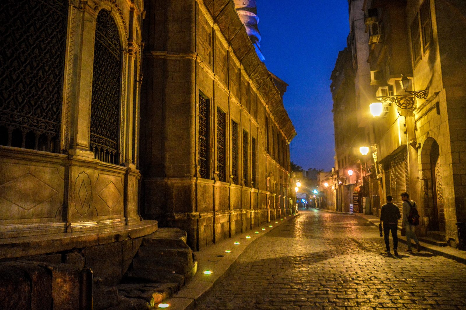
An audio walk through Cairo, down al Muizz Street from the northern gate of the old walled city past a sultan's hospital, the bazaar and al Azhar to the southern gate.
Narration in English · Stop 1 is free
 Tour no. 39
- Stops
- 10
- Distance
- 2.1 km (1.3 mi)
- Time
- About 110 minutes
- Route
- Easy city route
Listen before you buy
Stop 1 · Bab al-Futuh
Stop 1 is free. Listen before you buy.
The walk
An audio tour down al Muizz Street from the northern gate past the hospital of Qalawun, the bazaar and al Azhar to the southern gate, at your own pace
A thousand years ago al Muizz Street was the high street of a walled palace city, built for the Fatimid caliphs and closed to ordinary Cairenes, and it still runs about a kilometre from one stone gate to the other. The walk starts at Bab al Futuh, finished in 1087 when the vizier Badr al Jamali rebuilt the walls in stone, whose new names for the northern gates never stuck, and where the names of Bonaparte's officers were later carved near the top of the gates. It passes the mosque of al Hakim, which for centuries served as a prison, a stable and a school before volunteers of the Dawoodi Bohra, a Shia Muslim community based in India, began clearing it by hand in 1978. It then turns into a narrow lane to Bayt al Suhaymi, two houses of 1648 and the late eighteenth century joined into one, and comes back to the carved stone front of al Aqmar, a mosque of 1125.
Where the street forks stands a fountain of 1744 that gave water free to passers by, with a Qur'an school for orphan boys above it. On Bayn al Qasrayn, the open ground between the caliphs' two palaces, Sultan Qalawun built a hospital, a school and his own tomb in about thirteen months; the hospital admitted every Muslim, soldier or civilian, and gave patients money and clothing when they left, and an eye hospital still works on the site. The route turns through Khan el Khalili, where a sultan's master of the stables built a khan for merchants in the 1380s, past El Fishawy, where tea is still boiled in a basin of hot sand, to al Azhar, the mosque that became a school for students from across the Muslim world. It ends past the al Ghuri complex, whose builder died in battle in 1516 and was never buried in his tomb, at Bab Zuwayla, where the last Mamluk sultan, Tumanbay, was hanged in 1517, and where people once pressed teeth into the cracks of the doors in the hope of relief from toothache.
Route notes
The stops
About each stop · narration stays in the app
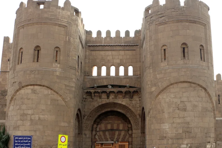
Photo: Sailko · Wikimedia Commons source · CC BY 3.0 · Cropped to the recorded 3:2 source rectangle and resized from the exact hash-bound source input. Bab al-Futuh
Bab al Futuh is the northern gate of the old Fatimid city, two round fronted stone towers on either side of an arched passage, built in 1087 for the vizier Badr al Jamali. The walk starts here because the gate and its partner Bab al Nasr, a short way east along the wall, show the stone vaults and finely cut masonry that were new to Islamic Egypt when they were built, and the platform between the towers has shafts in its floor through which boiling oil could be poured on attackers. The gate stands at a busy road and was restored with the northern wall in the early 2000s; the stop works from the street just inside it.
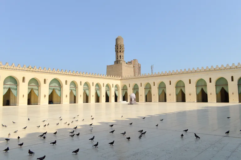
Photo: Francisco Anzola · Wikimedia Commons source · CC BY 2.0 · Cropped to the recorded 3:2 source rectangle and resized from the exact hash-bound source input. Mosque of al-Hakim
The mosque of al Hakim, which the Bohras call al Anwar, the Illuminated, is a Fatimid mosque begun in 990 and inaugurated in 1013, with a courtyard ringed by arcades and minarets encased in square stone bastions. The route stops here for a building that served the French as barracks and had a boys' school in part of its courtyard until 1980, and that is a place of daily prayer again after restorations by the Dawoodi Bohra, the latest finished in February 2023. It is a working mosque, open to visitors outside prayer times with shoes off, shoulders and knees covered and women's hair covered, and attendants remind visitors that it is for prayer alone; the stop works from the street in front.
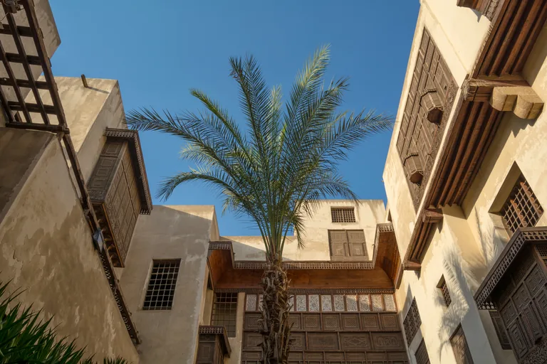
Photo: Metwallyphotos · Wikimedia Commons source · CC BY-SA 4.0 · Cropped to the recorded 3:2 source rectangle and resized from the exact hash-bound source input. Bayt Al-Suhaymi
Bayt al Suhaymi is a large house of the Ottoman period on Darb al Asfar, a narrow lane off al Muizz Street, built around a garden courtyard, with a roofed loggia for summer seating that faces north. The route stops here to show how a well off Cairo household lived behind a plain lane front: reception rooms for male guests on the ground floor, the private family quarters upstairs with a hall and a tiled bath where the women of the house met, kitchens in the west wing and storerooms for water and provision jars. The house is a museum and cultural centre with a ticket and its own hours, restored between 1996 and 2000; the stop works from the lane at the door, which is narrow and uneven.
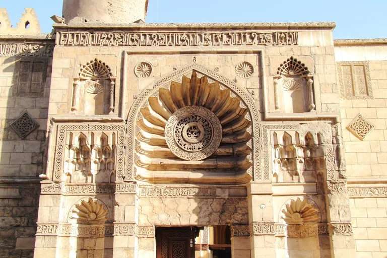
Photo: Djehouty · Wikimedia Commons source · CC BY-SA 4.0 · Cropped to the recorded 3:2 source rectangle and resized from the exact hash-bound source input. Al-Aqmar Mosque
Al Aqmar is a small Fatimid mosque of 1125, commissioned by the caliph al Amir and built under the supervision of his vizier, with a carved stone front on al Muizz Street. The route stops here for that carved front of niches, rosettes and a pierced medallion over the door; the mosque was restored by the Mamluk emir Yalbugha al Salimi in the 1390s and renewed in 1821, and a renovation finished in 2023 cleaned the soot from its stone and reinforced its dome. It is a working mosque, small and often closed between prayers, so the stop works from the street facing the façade.
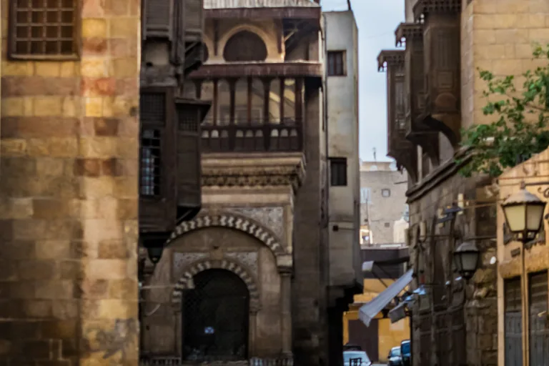
Photo: Yasser.mahmoud · Wikimedia Commons source · CC BY-SA 4.0 · Cropped to the recorded 3:2 source rectangle and resized from the exact hash-bound source input. Sabil-Kuttab of Abd al-Rahman Katkhuda
The Sabil Kuttab of Abd al Rahman Katkhuda, built in 1744 at the corner of al Muizz and Tambakshiya streets, has a water room behind copper grilles at street level, with marble basins for the cups, and a school room behind wooden arcades above. The route stops here for a building type found only in Cairo, a free public fountain with a Qur'an school for orphans above it, given by a prolific patron of Ottoman Cairo who decorated it with carved flowers and Ottoman style tiles. The building stands in the middle of a fork in the street, with motorbikes and handcarts passing on both sides, and its interior keeps its own hours.
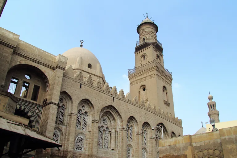
Photo: Djehouty · Wikimedia Commons source · CC BY-SA 4.0 · Cropped to the recorded 3:2 source rectangle and resized from the exact hash-bound source input. Complex of Qalawun
The complex of Sultan Qalawun, built in 1284 and 1285 on Bayn al Qasrayn, joins a hospital, a domed mausoleum and a madrasa that taught all four schools of Islamic law behind one long stone front on al Muizz Street. The route stops here for the hospital, which admitted all Muslims, soldiers and civilians, had departments for internal medicine, eye disease and surgery under a chief physician who licensed its doctors, and is an ophthalmology hospital today, beside the tomb where new emirs swore their oath. The complex is entered with a ticket; the stop works from the street in front of the mausoleum, and evening crowds on this stretch can be dense.
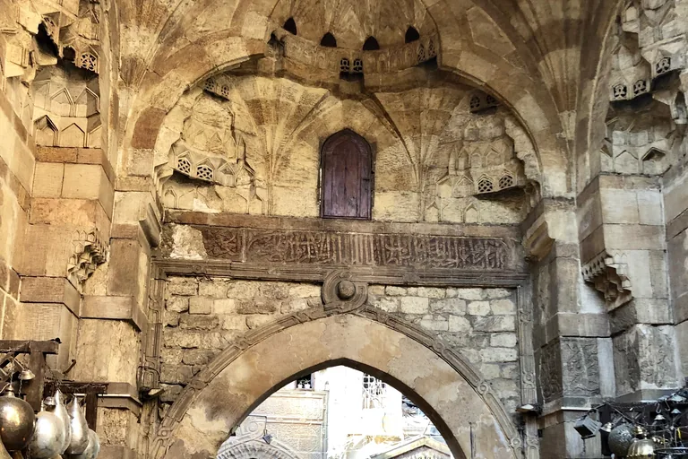
Photo: Warren LeMay · Wikimedia Commons source · CC0 1.0 · Cropped to the recorded 3:2 source rectangle and resized from the exact hash-bound source input. Khan el-Khalili
Khan el Khalili is the bazaar district beside al Muizz Street that takes its name from Jaharkas al Khalili, master of Sultan Barquq's stables, who built a khan there between 1382 and 1389, where the eastern palace of the Fatimid caliphs once stood. The route stops here for its crafts and its café: a three year project with UNESCO and the Cairo Governorate documented the crafts of the bazaar and of al Darb al Ahmar, among them copper lanterns that one family has made for almost a hundred years, and El Fishawy, a café near al Hussein Square founded in the eighteenth century, still serves tea boiled in sand. The lanes are narrow and crowded, with uneven paving and goods spilling from the shops, so mind the handcarts and motorbikes.
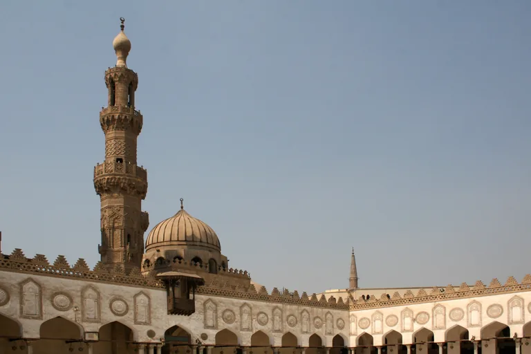
Photo: Diego Delso · Wikimedia Commons source · CC BY-SA 3.0 · Cropped to the recorded 3:2 source rectangle and resized from the exact hash-bound source input. Al-Azhar Mosque
Al Azhar is the Fatimid congregational mosque begun in 970, a courtyard ringed by arcades with prayer halls and minarets added over the centuries, among them those of the Mamluk sultans Qaytbay and al Ghuri, the second with a double top built in 1509. The route stops here for a thousand years of students: its residential halls were organised by nationality and school of law, each under a professor, al Azhar had some 6,000 foreign students from 75 countries in 1990, and a restoration paid for by a Saudi grant was completed in 2018. Reaching the mosque from the bazaar means crossing al Azhar Street, a wide road with fast traffic, so cross with great care; it is a working mosque, where shoes come off, shoulders and knees are covered and women cover their hair.
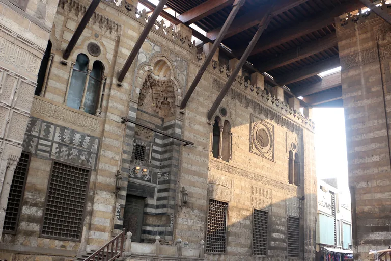
Photo: Sailko · Wikimedia Commons source · CC BY 3.0 · Cropped to the recorded 3:2 source rectangle and resized from the exact hash-bound source input. Al-Ghuri Complex
The al Ghuri complex is the pair of striped stone buildings that Sultan Qansuh al Ghuri built facing each other across al Muizz Street early in the sixteenth century: a mosque and madrasa raised above shops on one side, and his mausoleum, a Sufi hall and a fountain with a school on the other. The route stops here for the street the sultan rented out for market stalls under a roof between his two buildings, still sheltering a market of textiles and clothes, and for the Wikala al Ghuri, his caravanserai a few steps away, built in 1504 and 1505, where animals and goods were kept below and merchants lodged above. It is reached along al Azhar Street and then into the roofed market street, and the passage under the roof is often crowded with stalls.
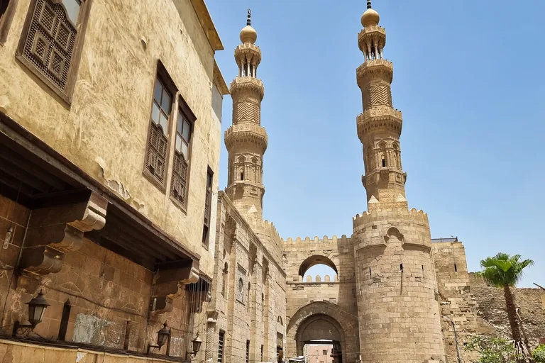
Photo: Richard Mortel · Wikimedia Commons source · CC BY 2.0 · Cropped to the recorded 3:2 source rectangle and resized from the exact hash-bound source input. Bab Zuwayla
Bab Zuwayla is the southern gate of the Fatimid city, rebuilt in stone in 1092 about a hundred metres south of the earlier gate, with the two minarets of the mosque of al Muayyad Shaykh, built between 1415 and 1421, standing on its towers. The route ends here, where the old street leaves the walled city: the gate's great wooden doors once turned on bronze ball bearings, the ground around it had risen nearly two metres before the restoration finished in 2003, and the covered tentmakers' street just beyond it sells hand stitched appliqué used for weddings, funerals, Ramadan and the Prophet's birthday. The street at the gate carries cars and motorbikes; the stop works from the street just north of the gate.


.jpg)


_(52087518412).jpg)
Local context
Before you go
The walk covers about two kilometres along al Muizz Street, almost all of it on the level. It starts at Bab al Futuh, the northern gate of the old walled city, and ends at Bab Zuwayla, the southern gate, with a short detour through the lanes of Khan el Khalili to al Azhar. The street is paved but busy, shared with handcarts and motorbikes, with shop fronts spilling into the lane and crowds in the evening. Between Khan el Khalili and al Azhar the route crosses al Azhar Street, a wide road with fast traffic.
On the ground
Access and surfaces
About two kilometres, almost all of it on the level, from the northern gate to the southern one along al Muizz Street, with a short detour through the bazaar to al Azhar. The street is paved but busy: expect handcarts, motorbikes, shop fronts spilling into the lane and crowds in the evening. Between Khan el Khalili and al Azhar the route crosses al Azhar Street, a wide road with fast traffic; cross with great care. Every stop works from the street. The mosques welcome visitors outside prayer times, with shoes off and shoulders and knees covered, and women are asked to cover their hair; the historic houses and some monuments charge for entry and keep their own hours.
Frequently asked
Plan the walk
- How long is the Cairo audio walking tour?
- Allow about 110 minutes. The route covers 2.1 km (1.3 mi) in 10 stops, including walking and listening time.
- Where does the Cairo tour start and end?
- It starts at Bab al Futuh, the northern gate of the old walled city on al Muizz Street, and ends at Bab Zuwayla, the southern gate at the other end of the same street.
- Is the route busy with traffic?
- In places. The street is paved and almost level but shared with handcarts and motorbikes, and between Khan el Khalili and al Azhar the route crosses al Azhar Street, a wide road with fast traffic, so cross with great care.
- Do I need to go inside the mosques or the historic houses?
- No. Every stop works from the street. The mosques welcome visitors outside prayer times, with shoes off and shoulders and knees covered, and women are asked to cover their hair; the historic houses and some monuments charge for entry and keep their own hours.
- Will the Cairo audio tour work offline?
- Yes, after download. Audio, stop text, images, and GPS triggering work without data; the live map background still needs a connection.