Évora · Alentejo, Portugal
Évora — Inside the Walls
An audio walk inside Évora's walls, from the Giraldo square past the Chapel of Bones and the Roman temple to the aqueduct people built their houses into.
Narration in English · Stop 1 is free
 Tour no. 33
- Stops
- 9
- Distance
- 2.5 km (1.6 mi)
- Time
- About 100 minutes
- Route
- Easy city route
Listen before you buy
Stop 1 · Praça do Giraldo
Stop 1 is free. Listen before you buy.
The walk
An audio tour inside Évora's walls, at your own pace
Little in Évora was left alone. The Roman temple spent about five hundred years as the city's butcher's shop, the last wing of the kings' palace became a theatre, the bones from the friars' burial grounds were set into the walls of a chapel, and people built their houses into the arches of the aqueduct. The walk starts in the Praça do Giraldo, where for centuries the city held its market, its fair and its bullfights, and where the Inquisition burned people it condemned; a memorial to its victims now stands near the marble fountain.
From there it goes down to the Chapel of Bones, whose door tells visitors that the bones inside are waiting for theirs, through the public garden laid out on the palace grounds, and up to a church front where four naked stone giants sit at the corners. Past the marble globe fountain of the Largo das Portas de Moura it reaches the Jesuit university, which a regiment of dragoons surrounded at nightfall on 8 February 1759 and which became a university again only in 1979, and then the cathedral, where by long tradition the bells were rung whenever a woman gave birth. After the columns of the Roman temple it comes down to the Rua do Cano, where houses fill the arches of the sixteenth century aqueduct whose water once ran on to the fountain where the walk began.
Route notes
The stops
About each stop · narration stays in the app
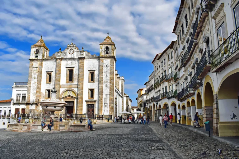
Photo: Jocelyn Erskine-Kellie from London, UK · Wikimedia Commons source · CC BY-SA 2.0 · Cropped to the recorded 3:2 source rectangle and resized from the exact hash-bound source input. Praça do Giraldo
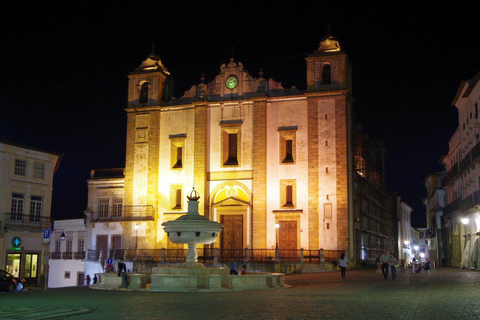
The Praça do Giraldo is the large square at the centre of Évora's old town, named in 1869 after Geraldo Sem Pavor, who took the city from the Muslims in 1165; its white marble fountain was built in 1571 by the architect Afonso Álvares. The walk begins here because the square has been a centre of city life since the thirteenth century, when the daily market was held on it, and for centuries it also hosted an annual fair; the loop ends a short walk away. It is a large, mostly level paved square with cars along its western side, and the fountain stands in front of the church of Santo Antão.
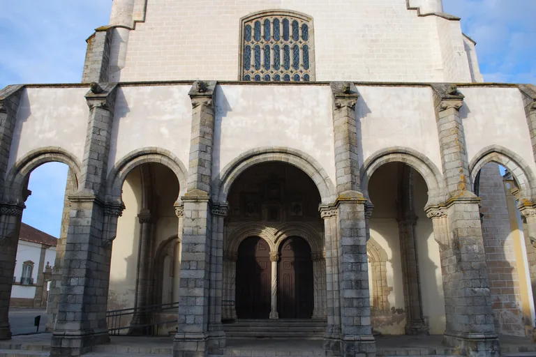
Photo: Concierge.2C · Wikimedia Commons source · CC BY-SA 3.0 · Cropped to the recorded 3:2 source rectangle and resized from the exact hash-bound source input. Church of São Francisco and the Chapel of Bones
The Church of São Francisco belonged to Évora's Franciscan convent and was rebuilt from the late fifteenth century under Afonso V, João II and Manuel I to suit the royal palace beside it; the Chapel of Bones inside dates from the seventeenth century. The route stops at its arcaded porch on the way down from the main square, because the public garden beside the church holds what survives of that royal palace, the next stop. The Chapel of Bones is inside, through the church's ticket desk and with its own opening hours, while the square in front slopes and the porch is reached by a few steps.
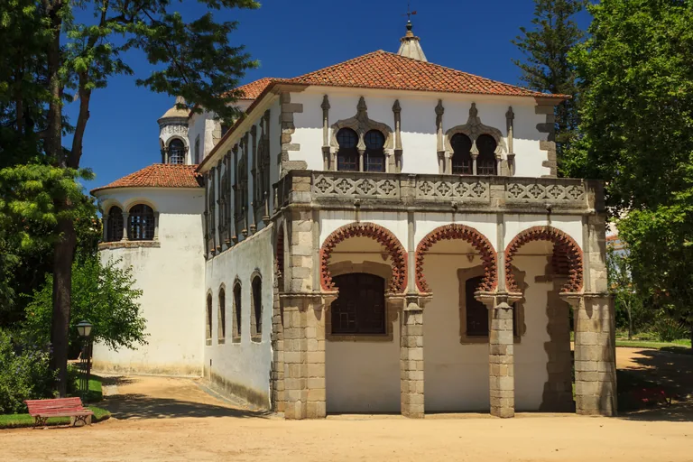
Photo: Pedro Paulo Palazzo · Wikimedia Commons source · CC BY-SA 2.0 · Cropped to the recorded 3:2 source rectangle and resized from the exact hash-bound source input. Palace of King Manuel
The Palace of King Manuel is the only surviving part of Évora's royal palace, a gallery of the early sixteenth century known as the Galeria das Damas, burnt out in 1916 and restored from 1943. The route crosses the public garden laid out around it from 1863 under the Italian architect Giuseppe Cinatti, which also has a cast iron bandstand opened in 1888. The garden is open in the daytime, with level sand and gravel paths, benches and most of the walk's shade, and the gallery is used by the city for official receptions and exhibitions.
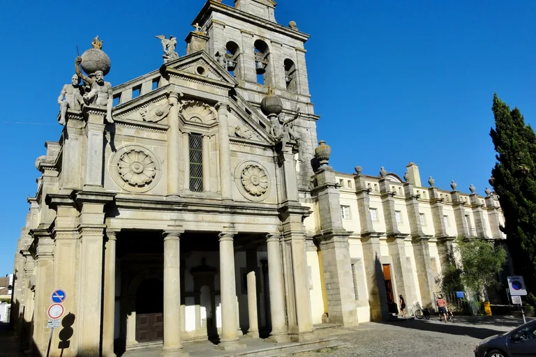
Photo: Jose Manuel · Wikimedia Commons source · CC BY-SA 4.0 · Cropped to the recorded 3:2 source rectangle and resized from the exact hash-bound source input. Church of Our Lady of Grace
The Church of Our Lady of Grace belonged to a convent of Augustinian hermits rebuilt in the 1530s with royal patronage, and Miguel de Arruda headed the works in the late 1530s. The route climbs to it for its sixteenth century front in local granite, with a porch in the manner of the Italian architectural treatises and four large seated stone figures on its upper corners. The convent buildings beside the church were put to other uses after the religious orders were abolished in 1834, and the small level square in front is partly used for parking.
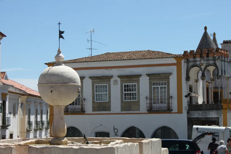
Photo: Nmmacedo · Wikimedia Commons source · CC BY-SA 3.0 · Cropped to the recorded 3:2 source rectangle and resized from the exact hash-bound source input. Largo das Portas de Moura
The Largo das Portas de Moura is a square by one of the old city gates, and its marble fountain, praised by the Cardinal Henrique in 1556, celebrates the water brought by the Água de Prata aqueduct. The route passes through it because titled noble families settled around it from the fourteenth century, making it, with the Praça do Giraldo, one of the main squares through which the city grew beyond its first walls. The square is open and level, but a road crosses it and traffic runs along one side.
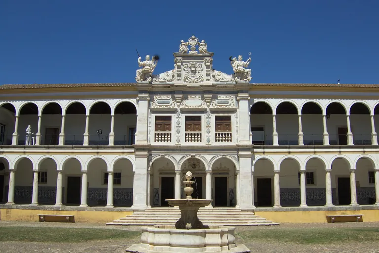
Photo: Nuno Curado from Belfast · Wikimedia Commons source · CC BY 2.0 · Cropped to the recorded 3:2 source rectangle and resized from the exact hash-bound source input. University of Évora
The Colégio do Espírito Santo was founded by the Cardinal Henrique, entrusted to the Jesuits and solemnly opened as Portugal's second university on 1 November 1559, a date the University of Évora still marks each year. It is on the route as a working part of the present University of Évora, refounded in 1979, with an arcaded courtyard behind the main entrance. The stop is made from the level street outside; the courtyard is reached through the main entrance and may need a ticket outside term time.
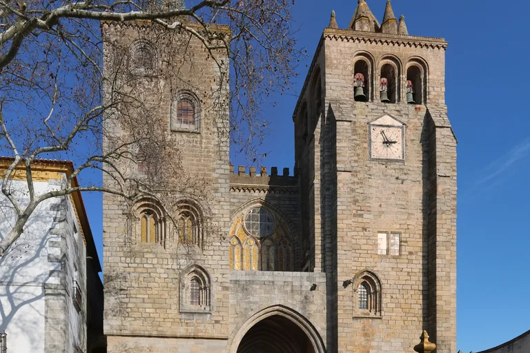
Photo: Ingo Mehling · Wikimedia Commons source · CC BY-SA 4.0 · Cropped to the recorded 3:2 source rectangle and resized from the exact hash-bound source input. Évora Cathedral
Évora Cathedral was built from about 1280 into the fourteenth century on the site of an earlier church, and its portal of the 1330s carries statues of the apostles by Mestre Pêro. The route climbs to it because it stands on the highest point of the old town, the hilltop it shares with the Roman temple that is the next stop. The portal is reached by steps, and the cathedral, its cloister and its roof are ticketed with their own opening hours, so the stop itself is made from the square in front.
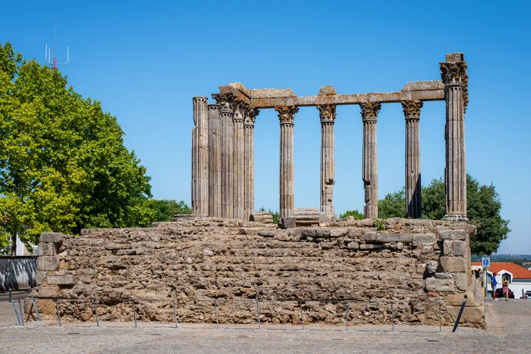
Photo: Norbert Nagel · Wikimedia Commons source · CC BY-SA 3.0 · Cropped to the recorded 3:2 source rectangle and resized from the exact hash-bound source input. Roman Temple of Évora
The Roman Temple of Évora, also known as the Temple of Diana, was begun in the first century AD and keeps its granite podium and a row of Corinthian columns on white marble bases. The route stops in the square around it, on the hilltop it shares with the cathedral, where the palace of the dukes of Cadaval and its Lóios church stand close by. The square is open, level and paved, and the podium is fenced, so the temple is seen from the square around it.
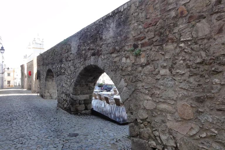
Photo: Bernardo Baggio · Wikimedia Commons source · CC BY 2.0 · Cropped to the recorded 3:2 source rectangle and resized from the exact hash-bound source input. Água de Prata Aqueduct
The Água de Prata Aqueduct was built for King João III to a design by the royal architect Francisco de Arruda and inaugurated in 1537, bringing water from springs near Graça do Divor; it runs for some twelve kilometres today. The route ends along its stretch in the Rua do Cano, where its arches run between the houses, a short walk from the Praça do Giraldo where the loop began. The Rua do Cano is a narrow cobbled street that carries traffic, and as in much of the old town the pavement is narrow or missing.


.jpg)

.jpg)
.JPG)


.jpg)
Local context
Before you go
This is a loop of about 2.5 km inside the city walls. It starts in the Praça do Giraldo and ends under the arches of the aqueduct in the Rua do Cano, a few minutes' walk from the square. The streets are mostly cobbled and gently sloping, with a few steeper lanes, including the short climb from the public garden up to the Church of Our Lady of Grace. Pavements are narrow or missing in the old streets, which carry some traffic; the Rua do Cano is a narrow cobbled street with cars, and houses are built into the arches, so keep to the street. The public garden has level paths, benches and shade; elsewhere there is little, and summer afternoons in the Alentejo are very hot.
On the ground
Access and surfaces
A loop of about two and a half kilometres inside the city walls, starting and ending near the Praça do Giraldo. The streets are mostly cobbled and gently sloping, with a few steeper lanes; pavements are narrow or missing in the old streets, which carry some traffic. Every stop works from the street and the audio is written that way. The Chapel of Bones and the cathedral have their own opening hours and are ticketed. Summer afternoons in the Alentejo are very hot, with little shade outside the public garden.
Frequently asked
Plan the walk
- How long is the Évora audio walking tour?
- Allow about 100 minutes. The route covers 2.5 km (1.6 mi) in 9 stops, including walking and listening time.
- Where does the Évora tour start and end?
- It starts in the Praça do Giraldo and ends under the arches of the Água de Prata Aqueduct in the Rua do Cano, a few minutes' walk from the square, so the route is a loop inside the city walls.
- Is there shade on the route in summer?
- Not much. The public garden around the Palace of King Manuel has shade and benches; elsewhere there is little, and summer afternoons in the Alentejo are very hot.
- Do I need to go inside the Chapel of Bones or the cathedral?
- No. Every stop works from the street. The Chapel of Bones and the cathedral have their own opening hours and tickets, and the university courtyard may need a ticket outside term time.
- Will the Évora audio tour work offline?
- Yes, after download. Audio, stop text, images, and GPS triggering work without data; the live map background still needs a connection.